IMAGES TAKEN NEAR TO
Langdale Gate, WITNEY, OX28 6FN
Introduction
This page details the photographs taken nearby to Langdale Gate, OX28 6FN by members of the Geograph project.
The Geograph project started in 2005 with the aim of publishing, organising and preserving representative images for every square kilometre of Great Britain, Ireland and the Isle of Man.

There are currently over 7.5m images from over14,400 individuals and you can help contribute to the project by visiting https://www.geograph.org.uk
Image Map (Loading...)


Getting Data...Please wait
Leaflet Map data © OpenStreetMap
Images are licensed for reuse under creativecommons.org/licenses/by-sa/2.0
Notes
- Clicking on the map will re-center to the selected point.
- The higher the marker number, the further away the image location is from the centre of the postcode.
Image Listing (298 Images Found)
Images are licensed for reuse under creativecommons.org/licenses/by-sa/2.0
Image
Details
Distance
1
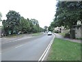
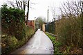
Witan Way - viewed from Langdale Gate
Image: © Betty Longbottom
Taken: 9 Aug 2013
0.05 miles
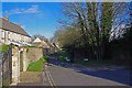
3
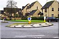
Roundabout on Witan Way, Witney, Oxon
The roundabout is on Witan Way, at its junction with Langdale Gate, which is the road going off to the right. The housing is in Langdale Gate.
Image: © P L Chadwick
Taken: 31 Jan 2016
0.07 miles
4

West Oxfordshire Early Intervention Service Hub, Witan Way, Witney, Oxon
This rather ugly looking building is home to Oxfordshire County Council's West Oxfordshire Early Intervention Service Hub. It offers services for children, young people, parents and families who are having difficulties in the Witney, Carterton, Chipping Norton, Burford, Eynsham and Woodstock areas. Hub is a fashionable word in local government at the moment. In days gone by it would have been called a centre.
Image: © P L Chadwick
Taken: 31 Jan 2016
0.07 miles
5

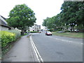
Witan Way - viewed from Langdale Gate
Image: © Betty Longbottom
Taken: 9 Aug 2013
0.08 miles
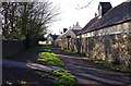
7
Crown Lane, Witney, Oxon
In this direction Crown Lane is heading for Witan Way. The lane carries a cycleway and a footpath. Behind the tall fence on the right is a large electricity substation.
Image: © P L Chadwick
Taken: 31 Jan 2016
0.09 miles
8
Farm Mill Lane, Witney, Oxon
In the foreground is an area for turning motor vehicles, as they can proceed no further along the lane. In this direction the lane leads to Witan Way. On the right is a dog waste bin.
Image: © P L Chadwick
Taken: 28 Mar 2016
0.10 miles
9
Farm Mill Lane, Witney, Oxon
This section of the lane is not open to motor vehicles. In this direction the lane is heading for Church Green.
Image: © P L Chadwick
Taken: 28 Mar 2016
0.10 miles
10
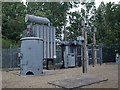
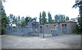
Electricity sub-station, Witney
Between Witan Way and the River Windrush.
Image: © Derek Harper
Taken: 27 Jun 2008
0.10 miles