IMAGES TAKEN NEAR TO
Park Road, WITNEY, OX28 6EN
Introduction
This page details the photographs taken nearby to Park Road, OX28 6EN by members of the Geograph project.
The Geograph project started in 2005 with the aim of publishing, organising and preserving representative images for every square kilometre of Great Britain, Ireland and the Isle of Man.

There are currently over 7.5m images from over14,400 individuals and you can help contribute to the project by visiting https://www.geograph.org.uk
Image Map (Loading...)


Getting Data...Please wait
Leaflet Map data © OpenStreetMap
Images are licensed for reuse under creativecommons.org/licenses/by-sa/2.0
Notes
- Clicking on the map will re-center to the selected point.
- The higher the marker number, the further away the image location is from the centre of the postcode.
Image Listing (38 Images Found)
Images are licensed for reuse under creativecommons.org/licenses/by-sa/2.0
Image
Details
Distance
1
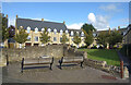
Site of the former Witney Workhouse
Housing is now on the site once occupied by a municipal workhouse, In the central courtyard a remnant of wall with a couple of seats surrounds a small metal plaque recounting the history of the place. This is shown here Image
Image: © Des Blenkinsopp
Taken: 15 Oct 2020
0.08 miles
2
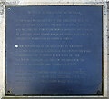
Witney Workhouse Memorial
In the courtyard of a new housing development on the site of a former workhouse, a small plaque tells the history of the place.
Image: © Des Blenkinsopp
Taken: 15 Oct 2020
0.08 miles
3
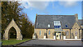
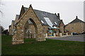
The Workhouse Chapel
The site of a 19th century workhouse is now housing. All that remains is the old chapel which has been converted to offices, and what looks like an old gateway.
Image: © Des Blenkinsopp
Taken: 15 Oct 2020
0.09 miles
4
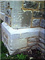
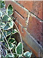
Benchmark on a buttress of The Old Chapel, Union Way
Ordnance Survey cut mark benchmark discussed on the Bench Mark Database at http://www.bench-marks.org.uk/bm37241
Image: © Roger Templeman
Taken: 5 Mar 2011
0.10 miles
5
Arch and office building at junction of Union Way and Tower Hill
The history of the site which now has this converted chapel as offices is interesting. Witney Workhouse was built on Razor Hill (now Tower Hill) in 1835-36 by the architect George Wilkinson. It had four wings radiating from an octagonal central building. George's younger brother William added a separate chapel in 1860. During the First World War the workhouse housed prisoners of war. In 1940 it became Crawford Collets engineering factory which incorporated the chapel as the factory canteen. In 1979 Crawford Collets demolished the main buildings and replaced them with a modern factory but preserved the entrance gate and former chapel. In 2004 this factory was demolished for redevelopment. The gate and chapel were preserved and subsequently the chapel renovated to provide the offices of this photograph.
Image: © Roger Templeman
Taken: 5 Mar 2011
0.10 miles
6
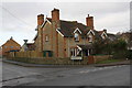
Houses at Tower Hill / Windrush Valley Road junction
There is an OS benchmark Image on the near corner, left hand face, of the house at the junction
Image: © Roger Templeman
Taken: 4 Jan 2017
0.10 miles
7
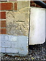
Benchmark on #32 Tower Hill
Ordnance Survey cut mark benchmark described on the Bench Mark Database at http://www.bench-marks.org.uk/bm37239
Image: © Roger Templeman
Taken: 5 Mar 2011
0.10 miles
8
Benchmark on #55 Burford Road
Ordnance Survey cut mark benchmark described on the Bench Mark Database at http://www.bench-marks.org.uk/bm37236
Image: © Roger Templeman
Taken: 5 Mar 2011
0.12 miles
9
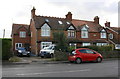
Houses on south side of Burford Road
There is an OS benchmark Image on the side of the left hand house near its front corner
Image: © Roger Templeman
Taken: 4 Jan 2017
0.12 miles
10
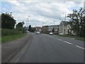
Witney - Burford Road (B4047) about to meet the A4095
Image: © Peter Whatley
Taken: 21 May 2011
0.13 miles