IMAGES TAKEN NEAR TO
Mill Street, WITNEY, OX28 6DQ
Introduction
This page details the photographs taken nearby to Mill Street, OX28 6DQ by members of the Geograph project.
The Geograph project started in 2005 with the aim of publishing, organising and preserving representative images for every square kilometre of Great Britain, Ireland and the Isle of Man.

There are currently over 7.5m images from over14,400 individuals and you can help contribute to the project by visiting https://www.geograph.org.uk
Image Map (Loading...)


Getting Data...Please wait
Leaflet Map data © OpenStreetMap
Images are licensed for reuse under creativecommons.org/licenses/by-sa/2.0
Notes
- Clicking on the map will re-center to the selected point.
- The higher the marker number, the further away the image location is from the centre of the postcode.
Image Listing (89 Images Found)
Images are licensed for reuse under creativecommons.org/licenses/by-sa/2.0
Image
Details
Distance

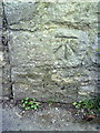
2
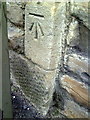
Benchmark on building in Mill Street
Ordnance Survey cut mark benchmark described on the Bench Mark Database at http://www.bench-marks.org.uk/bm37233
Image: © Roger Templeman
Taken: 5 Mar 2011
0.02 miles
3
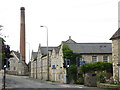
Former Woodford Mill, Witney
This was the last working blanket mill in Witney and closed in 2002. It has now been redeveloped for housing with the weaving sheds replaced by new houses. These buildings seen here are all part of the original complex and have been reused. It is particularly satisfying to see that the chimney has been retained.
Image: © Chris Allen
Taken: 19 Aug 2017
0.03 miles
4
Former blanket Mill, Witney
This was the last working blanket mill in Witney and closed in 2002. It has now been redeveloped for housing with the weaving sheds replaced by new houses. These buildings seen here are all part of the original complex and have been reused. It is particularly satisfying to see that the chimney has been retained.
Image: © Chris Allen
Taken: 19 Aug 2017
0.03 miles
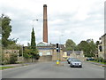
5
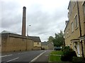
Blanket mill chimney
View along A4059 - Mill Street, Witney.
Image: © Alan Hughes
Taken: 16 Sep 2019
0.04 miles
6
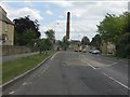
Witney - Burford Road (A4095) at Dark Lane
Image: © Peter Whatley
Taken: 21 May 2011
0.05 miles
7
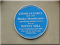
Former blanket mill - blue plaque
This is on one of the original buildings on Mill Street and is self-explanatory.
Image: © Chris Allen
Taken: 19 Aug 2017
0.05 miles
8
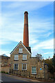
Woodford Mill
Mill and Chimney in Whitney.
Image: © Wayland Smith
Taken: 30 Oct 2021
0.06 miles
9
Former Woodford Mill, Witney
This was the last working blanket mill in Witney and closed in 2002. It has now been redeveloped for housing with the weaving sheds replaced by new houses. It is particularly satisfying to see that the chimney has been retained.
Image: © Chris Allen
Taken: 19 Aug 2017
0.06 miles
10
Benchmark on #41 Mill Street
Ordnance Survey cut mark benchmark described on the Bench Mark Database at http://www.bench-marks.org.uk/bm37232
Image: © Roger Templeman
Taken: 5 Mar 2011
0.07 miles