IMAGES TAKEN NEAR TO
Burford Road, WITNEY, OX28 6DH
Introduction
This page details the photographs taken nearby to Burford Road, OX28 6DH by members of the Geograph project.
The Geograph project started in 2005 with the aim of publishing, organising and preserving representative images for every square kilometre of Great Britain, Ireland and the Isle of Man.

There are currently over 7.5m images from over14,400 individuals and you can help contribute to the project by visiting https://www.geograph.org.uk
Image Map (Loading...)


Getting Data...Please wait
Leaflet Map data © OpenStreetMap
Images are licensed for reuse under creativecommons.org/licenses/by-sa/2.0
Notes
- Clicking on the map will re-center to the selected point.
- The higher the marker number, the further away the image location is from the centre of the postcode.
Image Listing (28 Images Found)
Images are licensed for reuse under creativecommons.org/licenses/by-sa/2.0
Image
Details
Distance
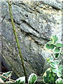
1
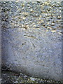
Benchmark on #18 Burford Road
Ordnance Survey cut mark benchmark described on the Bench Mark Database at http://www.bench-marks.org.uk/bm37235
Image: © Roger Templeman
Taken: 5 Mar 2011
0.00 miles
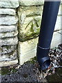
5
Benchmark on #20 Dark Lane
Ordnance Survey cut mark benchmark described on the Bench Mark Database at http://www.bench-marks.org.uk/bm37211
Image: © Roger Templeman
Taken: 5 Mar 2011
0.15 miles
6
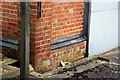
Benchmark on the Thames Water Pumping Station, Dark Lane
Ordnance Survey cut mark benchmark described on the Bench Mark Database at http://www.bench-marks.org.uk/bm37212
Image: © Roger Templeman
Taken: 5 Mar 2011
0.17 miles
7
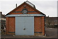
Thames Water Witney Pumping Station, Dark Lane
Photo taken from Moor Avenue. The Ordnance Survey benchmark on the corner to the left of the doors is shown at Image
Image: © Roger Templeman
Taken: 5 Mar 2011
0.17 miles
8
Benchmark on building on north side of Mill Street opposite Woodford Way
Ordnance Survey cut mark benchmark described on the Bench Mark Database at http://www.bench-marks.org.uk/bm37259
Image: © Roger Templeman
Taken: 10 Mar 2011
0.17 miles
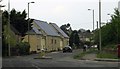
9
Welch Way
Welch Way and Witney Community Hospital in the background.
Image: © Miranda Hodgson
Taken: 6 Jan 2010
0.17 miles
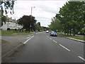
10
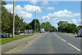
A4095 Burford Road, Witney
Heading east.
Image: © Robin Webster
Taken: 22 Aug 2020
0.18 miles