IMAGES TAKEN NEAR TO
Colwell Drive, WITNEY, OX28 5NQ
Introduction
This page details the photographs taken nearby to Colwell Drive, OX28 5NQ by members of the Geograph project.
The Geograph project started in 2005 with the aim of publishing, organising and preserving representative images for every square kilometre of Great Britain, Ireland and the Isle of Man.

There are currently over 7.5m images from over14,400 individuals and you can help contribute to the project by visiting https://www.geograph.org.uk
Image Map
Images are licensed for reuse under creativecommons.org/licenses/by-sa/2.0
Notes
- Clicking on the map will re-center to the selected point.
- The higher the marker number, the further away the image location is from the centre of the postcode.
Image Listing (22 Images Found)
Images are licensed for reuse under creativecommons.org/licenses/by-sa/2.0
Image
Details
Distance
5
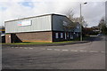
Tiles 2U warehouse on Thorney Leys Trading Estate
The ahead road is Thorney Leys Park which joins Thorney Leys at its far end.
Image: © Roger Templeman
Taken: 10 Mar 2011
0.15 miles
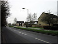
7
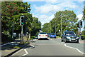
Foot and cycle crossing, Ducklington Lane, Witney
The A415.
Image: © Robin Webster
Taken: 22 Aug 2020
0.17 miles
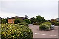
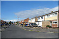
9

Lidl (1), Ducklington Lane, Witney, Oxon
Local branch of the Lidl discount supermarket chain.
Image
Image: © P L Chadwick
Taken: 24 Jul 2016
0.18 miles