IMAGES TAKEN NEAR TO
Bramley Heights, WITNEY, OX28 5JL
Introduction
This page details the photographs taken nearby to Bramley Heights, OX28 5JL by members of the Geograph project.
The Geograph project started in 2005 with the aim of publishing, organising and preserving representative images for every square kilometre of Great Britain, Ireland and the Isle of Man.

There are currently over 7.5m images from over14,400 individuals and you can help contribute to the project by visiting https://www.geograph.org.uk
Image Map (Loading...)


Getting Data...Please wait
Leaflet Map data © OpenStreetMap
Images are licensed for reuse under creativecommons.org/licenses/by-sa/2.0
Notes
- Clicking on the map will re-center to the selected point.
- The higher the marker number, the further away the image location is from the centre of the postcode.
Image Listing (31 Images Found)
Images are licensed for reuse under creativecommons.org/licenses/by-sa/2.0
Image
Details
Distance
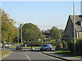
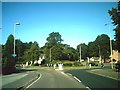
1

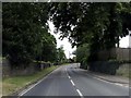
Witney - Curbridge Road approaching the roundabout
Image: © Peter Whatley
Taken: 15 Oct 2011
0.04 miles
2
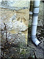
Benchmark on #20 Ducklington Lane
Ordnance Survey cut mark benchmark described on the Bench Mark Database at http://www.bench-marks.org.uk/bm37250
Image: © Roger Templeman
Taken: 5 Mar 2011
0.04 miles
3
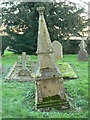
Roberts' family tomb, cemetery, Co-operative Funeral Service, Witney (1)
This unusual memorial (calling it a gravestone or even a tomb seems inadequate) is showing the passage of time.
Image: © Brian Robert Marshall
Taken: 28 Nov 2006
0.04 miles
4
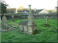
Roberts' family tomb, cemetery, Co-operative Funeral Service, Witney (2)
Another view showing the degree of lean on this tomb.
Image: © Brian Robert Marshall
Taken: 28 Nov 2006
0.04 miles
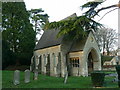
5
Another former chapel, Co-operative Funeral Service, Witney
This chapel is adjacent to Curbridge Road, Witney.
Image: © Brian Robert Marshall
Taken: 28 Nov 2006
0.04 miles
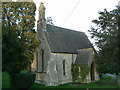
6
Former chapel, Co-operative Funeral Service, Witney
This chapel is one of two within a few metres of each other on the same site. This one is adjacent to Tower Hill. The bungalow to its right is in Beech Road.
Image: © Brian Robert Marshall
Taken: 28 Nov 2006
0.08 miles
8
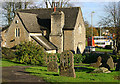
Witney Cemetery Lodge
The Lodge on the edge of Witney's Victorian Cemetery. A bus negotiates the roundabout at the end of Corn Street in the background.
Image: © Martin Loader
Taken: 16 Nov 2005
0.09 miles
9
Approaching the roundabout
Along Corn Street, Witney.
Image: © andrew auger
Taken: 12 Sep 2009
0.11 miles