IMAGES TAKEN NEAR TO
Burwell Meadow, WITNEY, OX28 5JG
Introduction
This page details the photographs taken nearby to Burwell Meadow, OX28 5JG by members of the Geograph project.
The Geograph project started in 2005 with the aim of publishing, organising and preserving representative images for every square kilometre of Great Britain, Ireland and the Isle of Man.

There are currently over 7.5m images from over14,400 individuals and you can help contribute to the project by visiting https://www.geograph.org.uk
Image Map
Images are licensed for reuse under creativecommons.org/licenses/by-sa/2.0
Notes
- Clicking on the map will re-center to the selected point.
- The higher the marker number, the further away the image location is from the centre of the postcode.
Image Listing (13 Images Found)
Images are licensed for reuse under creativecommons.org/licenses/by-sa/2.0
Image
Details
Distance
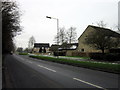
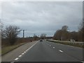
5
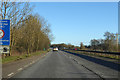
A40 towards Oxford
Approaching the A415 junction, Witney.
Image: © Robin Webster
Taken: 19 Jan 2020
0.12 miles
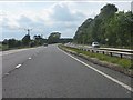
6
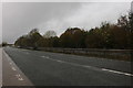
The A40 by Witney
My earlier visit here https://www.geograph.org.uk/photo/3577254
Image: © David Howard
Taken: 2 Nov 2019
0.13 miles