IMAGES TAKEN NEAR TO
Elm Close, WITNEY, OX28 5BT
Introduction
This page details the photographs taken nearby to Elm Close, OX28 5BT by members of the Geograph project.
The Geograph project started in 2005 with the aim of publishing, organising and preserving representative images for every square kilometre of Great Britain, Ireland and the Isle of Man.

There are currently over 7.5m images from over14,400 individuals and you can help contribute to the project by visiting https://www.geograph.org.uk
Image Map (Loading...)


Getting Data...Please wait
Leaflet Map data © OpenStreetMap
Images are licensed for reuse under creativecommons.org/licenses/by-sa/2.0
Notes
- Clicking on the map will re-center to the selected point.
- The higher the marker number, the further away the image location is from the centre of the postcode.
Image Listing (6 Images Found)
Images are licensed for reuse under creativecommons.org/licenses/by-sa/2.0
Image
Details
Distance
3
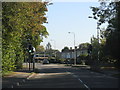
Witney
Looking west over the huge Burwell Farm Estate from close to the A415 road
Image: © Brendan and Ruth McCartney
Taken: Unknown
0.12 miles
4
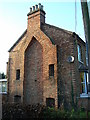
Gable end 96 Tower Hill Witney
Did the builder run out of money or time before finishing the terrace?
Image: © Brian Robert Marshall
Taken: 28 Nov 2006
0.22 miles
5
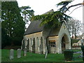
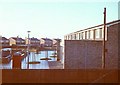
Former chapel, Co-operative Funeral Service, Witney
This chapel is one of two within a few metres of each other on the same site. This one is adjacent to Tower Hill. The bungalow to its right is in Beech Road.
Image: © Brian Robert Marshall
Taken: 28 Nov 2006
0.22 miles
6
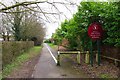
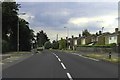
Public footpath & cycleway to Apley Way, Witney, Oxon
This route on the Deer Park Estate also gives access to West Witney Primary School & Nursery.
Image
Image: © P L Chadwick
Taken: 18 Feb 2018
0.24 miles