IMAGES TAKEN NEAR TO
Vale Road, WITNEY, OX28 5AZ
Introduction
This page details the photographs taken nearby to Vale Road, OX28 5AZ by members of the Geograph project.
The Geograph project started in 2005 with the aim of publishing, organising and preserving representative images for every square kilometre of Great Britain, Ireland and the Isle of Man.

There are currently over 7.5m images from over14,400 individuals and you can help contribute to the project by visiting https://www.geograph.org.uk
Image Map
Images are licensed for reuse under creativecommons.org/licenses/by-sa/2.0
Notes
- Clicking on the map will re-center to the selected point.
- The higher the marker number, the further away the image location is from the centre of the postcode.
Image Listing (29 Images Found)
Images are licensed for reuse under creativecommons.org/licenses/by-sa/2.0
Image
Details
Distance
1
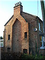
Gable end 96 Tower Hill Witney
Did the builder run out of money or time before finishing the terrace?
Image: © Brian Robert Marshall
Taken: 28 Nov 2006
0.10 miles
2
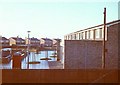
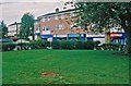
Witney
Looking west over the huge Burwell Farm Estate from close to the A415 road
Image: © Brendan and Ruth McCartney
Taken: Unknown
0.13 miles
3
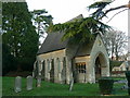
Former chapel, Co-operative Funeral Service, Witney
This chapel is one of two within a few metres of each other on the same site. This one is adjacent to Tower Hill. The bungalow to its right is in Beech Road.
Image: © Brian Robert Marshall
Taken: 28 Nov 2006
0.13 miles
4
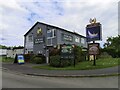
The Rowing Machine on Fettiplace Road
The Rowing Machine is a former Morrells pub.
Image: © Steve Daniels
Taken: 26 May 2021
0.14 miles
5
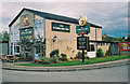
The Rowing Machine, Fettiplace Road, Witney
This is a typical estate pub of the 1950's/1960's, and has had its ups & downs over the years. It has been part of the Hungry Horse chain of pub/restaurants for some years, but in December 2009 it re-opened under the direct control of the owners, brewery Greene King of Bury St. Edmunds in Suffolk. There were considerable improvements made at that time, including provision of a large restaurant. Despite that, there has been at least one change of landlord since then. In many ways, the middle of a housing estate is perhaps a strange place for a restaurant, as there would be no passing trade here.
The pub's name is derived from Witney's famous former blanket making industry. Rowing is raising the nap on blankets. In Witney it was pronounced a bit like ploughing. At one time the pub was called the Flying Machine.
Image: © P L Chadwick
Taken: 28 Aug 2011
0.15 miles
6
The Rowing Machine
A suburban local pub in the Hungry Horse estate. See Image for more info, including the unusual name.
Image: © Des Blenkinsopp
Taken: 15 Oct 2020
0.15 miles
7
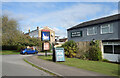
Local shops, Fettiplace Road, Witney
Behind the grassed area, is a parade of shops serving the surrounding housing estate. The shops include a local Tesco, the Oasis Coffee Shop, The Babywarehouse, Dolphin Fish Shop (fish and chips), States Fishing Tackle, and Betfred (bookmakers).
Image: © P L Chadwick
Taken: 28 Aug 2011
0.17 miles
8
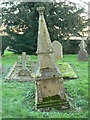
Roberts' family tomb, cemetery, Co-operative Funeral Service, Witney (1)
This unusual memorial (calling it a gravestone or even a tomb seems inadequate) is showing the passage of time.
Image: © Brian Robert Marshall
Taken: 28 Nov 2006
0.19 miles
9
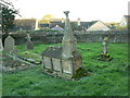
Roberts' family tomb, cemetery, Co-operative Funeral Service, Witney (2)
Another view showing the degree of lean on this tomb.
Image: © Brian Robert Marshall
Taken: 28 Nov 2006
0.19 miles
10
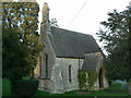
Another former chapel, Co-operative Funeral Service, Witney
This chapel is adjacent to Curbridge Road, Witney.
Image: © Brian Robert Marshall
Taken: 28 Nov 2006
0.19 miles