IMAGES TAKEN NEAR TO
Avenue Four, WITNEY, OX28 4BN
Introduction
This page details the photographs taken nearby to Avenue Four, OX28 4BN by members of the Geograph project.
The Geograph project started in 2005 with the aim of publishing, organising and preserving representative images for every square kilometre of Great Britain, Ireland and the Isle of Man.

There are currently over 7.5m images from over14,400 individuals and you can help contribute to the project by visiting https://www.geograph.org.uk
Image Map (Loading...)


Getting Data...Please wait
Leaflet Map data © OpenStreetMap
Images are licensed for reuse under creativecommons.org/licenses/by-sa/2.0
Notes
- Clicking on the map will re-center to the selected point.
- The higher the marker number, the further away the image location is from the centre of the postcode.
Image Listing (108 Images Found)
Images are licensed for reuse under creativecommons.org/licenses/by-sa/2.0
Image
Details
Distance
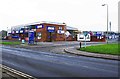
1
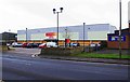
Poundstretcher & Pet Hut, Station Lane, Witney, Oxon
Poundstretcher sells household products and garden essentials. The Pet Hut which is within the Poundstretcher store sells food and other items for domestic pets.
Image: © P L Chadwick
Taken: 18 Feb 2018
0.10 miles
2
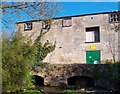
Old Mill on the Windrush
This derelict mill is over a millstream running beside the main river which is a short way to the east.
The bridge now gives access to a riverside park.
Image: © Des Blenkinsopp
Taken: 15 Apr 2012
0.11 miles
3
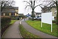
Footpath and cycleway adjacent to Station Lane, Witney, Oxon
The building on the left is part of Sainsbury's superstore.
Image: © P L Chadwick
Taken: 18 Feb 2018
0.11 miles
4
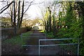
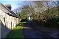
Entrance to Farm Mill Lane, Witney, Oxon
This is the Witan Way entrance to the main part of Farm Mill Lane, which in this direction is heading for Church Green. Witan Way is a fairly modern road and its construction split the lane into two sections. A small section is on the other side of Witan Way and leads to the former mill, which has been converted into apartments.
Image: © P L Chadwick
Taken: 28 Mar 2016
0.13 miles
5
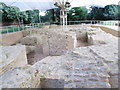
Remains of Bishop's Palace - off Church Green
Remains of Palace built for Bishop of Winchester in 12th Century.
Image: © Betty Longbottom
Taken: 9 Aug 2013
0.13 miles
7
Farm Mill Lane, Witney, Oxon
The lane in this direction is heading for Witan Way, which is in the far distance.
Image: © P L Chadwick
Taken: 28 Mar 2016
0.13 miles
8
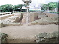
Remains of Bishop's Palace - off Church Green
Remains of Palace built for Bishop of Winchester in 12th Century.
Image: © Betty Longbottom
Taken: 9 Aug 2013
0.13 miles
9
Jewson, Station Lane, Witney, Oxon
A branch of the nationwide builders merchants. Located on the corner of Station Lane and Avenue Three of the Station Lane Industrial Estate. Unfortunately both station and railway closed decades ago.
Image: © P L Chadwick
Taken: 18 Feb 2018
0.13 miles
10
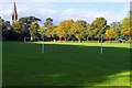
Football pitch, Leys Recreation Ground, Station Lane, Witney, Oxon
This football pitch is at the eastern end of this popular recreation ground. In the background is the spire of the parish church.
Image: © P L Chadwick
Taken: 9 Oct 2016
0.13 miles