IMAGES TAKEN NEAR TO
Stanton Harcourt Road, WITNEY, OX28 3LE
Introduction
This page details the photographs taken nearby to Stanton Harcourt Road, OX28 3LE by members of the Geograph project.
The Geograph project started in 2005 with the aim of publishing, organising and preserving representative images for every square kilometre of Great Britain, Ireland and the Isle of Man.

There are currently over 7.5m images from over14,400 individuals and you can help contribute to the project by visiting https://www.geograph.org.uk
Image Map (Loading...)


Getting Data...Please wait
Leaflet Map data © OpenStreetMap
Images are licensed for reuse under creativecommons.org/licenses/by-sa/2.0
Notes
- Clicking on the map will re-center to the selected point.
- The higher the marker number, the further away the image location is from the centre of the postcode.
Image Listing (75 Images Found)
Images are licensed for reuse under creativecommons.org/licenses/by-sa/2.0
Image
Details
Distance
1
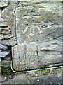
Benchmark on side of #23 Stanton Harcourt Road
Ordnance Survey cut mark benchmark described on the Bench Mark Database at http://www.bench-marks.org.uk/bm37178
Image: © Roger Templeman
Taken: 1 Mar 2011
0.02 miles
3

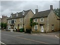
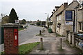
The Griffin (1), 166 Newland, Witney, Oxon
The Griffin, formerly the Griffin Inn, is a traditional local pub and is owned by the famous Devizes, Wiltshire, brewery of Wadworth's. It came into their ownership in 1969 when they took over the Garne's of Burford brewery. The pub, one of only two surviving in Newland, opened in 1786. It is the only Wadworth's pub in Witney. The building is Grade II listed and according to the listing text dates from around 1750/60, so probably was a house for a few years before it became a pub.
Image
Image: © P L Chadwick
Taken: 19 Jun 2016
0.09 miles
4

The Griffin (2) - sign, 166 Newland, Witney, Oxon
Named after the mythological creature which dates back at least five thousand years. Judging by this rather splendid sign you wouldn't want to bump into this creature on a dark night!
Image
Image: © P L Chadwick
Taken: 19 Jun 2016
0.09 miles
7
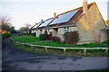
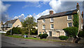
Solar panels on bungalows in Wadard's Meadow, Witney, Oxon
The three bungalows nearest the camera have large solar panels on their rooves (or roofs, if you prefer). The large housing estate known as Wadard's Meadow is named after a Norman knight who apparently came over to England with William the Conqueror. Wadard held lands in Oxfordshire and elsewhere and is depicted on the Bayeux Tapestry. But little else seems to be known about him.
Image: © P L Chadwick
Taken: 19 Jan 2020
0.11 miles
8
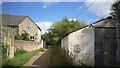
Footpath beside the Madley Brook
The Madley Brook is a small stream in a very overgrown and neglected channel to the right of the path, behind the derelict shed.
Image: © Des Blenkinsopp
Taken: 17 Aug 2015
0.12 miles
9
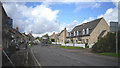
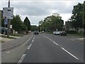
Newlands, Witney
Looking towards town from outside The Griffin pub.
The bus is about on the grid line.
Image: © Des Blenkinsopp
Taken: 17 Aug 2015
0.12 miles