IMAGES TAKEN NEAR TO
Woodbank, WITNEY, OX28 1UH
Introduction
This page details the photographs taken nearby to Woodbank, OX28 1UH by members of the Geograph project.
The Geograph project started in 2005 with the aim of publishing, organising and preserving representative images for every square kilometre of Great Britain, Ireland and the Isle of Man.

There are currently over 7.5m images from over14,400 individuals and you can help contribute to the project by visiting https://www.geograph.org.uk
Image Map
Images are licensed for reuse under creativecommons.org/licenses/by-sa/2.0
Notes
- Clicking on the map will re-center to the selected point.
- The higher the marker number, the further away the image location is from the centre of the postcode.
Image Listing (4 Images Found)
Images are licensed for reuse under creativecommons.org/licenses/by-sa/2.0
Image
Details
Distance
1
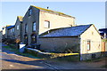
New housing on Northfield Farm site
Image: © Roger Templeman
Taken: 29 Dec 2014
0.03 miles
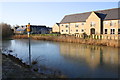
3
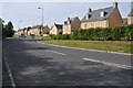
Harvest Way, Witney
Modern housing development on Harvest Way off Jubilee Way on the edge of Witney.
Image: © Philip Halling
Taken: 28 May 2011
0.21 miles
4
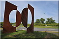
Modern art, Jubilee Way, Witney
This artistic object stands on the site of Jubilee Way at the junction of Harvest Way. I have tried to find out more about it but with no success, Can anyone help?
Image: © Philip Halling
Taken: 28 May 2011
0.23 miles