IMAGES TAKEN NEAR TO
New Yatt Road, WITNEY, OX28 1TB
Introduction
This page details the photographs taken nearby to New Yatt Road, OX28 1TB by members of the Geograph project.
The Geograph project started in 2005 with the aim of publishing, organising and preserving representative images for every square kilometre of Great Britain, Ireland and the Isle of Man.

There are currently over 7.5m images from over14,400 individuals and you can help contribute to the project by visiting https://www.geograph.org.uk
Image Map (Loading...)


Getting Data...Please wait
Leaflet Map data © OpenStreetMap
Images are licensed for reuse under creativecommons.org/licenses/by-sa/2.0
Notes
- Clicking on the map will re-center to the selected point.
- The higher the marker number, the further away the image location is from the centre of the postcode.
Image Listing (7 Images Found)
Images are licensed for reuse under creativecommons.org/licenses/by-sa/2.0
Image
Details
Distance
1
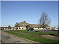
The King's School, primary school
Run by the Oxfordshire Community Churches.
Image: © Jonathan Billinger
Taken: 23 Jan 2007
0.08 miles
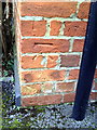
2
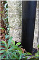
Benchmark on 'Meadow Cottage'
Ordnance Survey cut mark benchmark described on the Bench Mark Database at http://www.bench-marks.org.uk/bm63436
Image: © Roger Templeman
Taken: 29 Dec 2014
0.09 miles
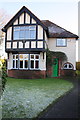
3
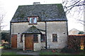
'Meadow Cottage', New Yatt Road
There is an OS benchmark Image on the right hand side of the house near its front corner
Image: © Roger Templeman
Taken: 29 Dec 2014
0.09 miles
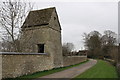
5
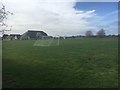
Playing Fields
King's School Playing Fields
Image: © Shaun Ferguson
Taken: 9 Mar 2019
0.10 miles
6
Benchmark on #50 New Yatt Road
Ordnance Survey cut mark benchmark described on the Bench Mark Database at http://www.bench-marks.org.uk/bm37179
Image: © Roger Templeman
Taken: 1 Mar 2011
0.18 miles
7
#50 New Yatt Road
There is an OS benchmark Image on the right hand side of the house near its front corner
Image: © Roger Templeman
Taken: 29 Dec 2014
0.19 miles