IMAGES TAKEN NEAR TO
Chestnut Close, WITNEY, OX28 1PD
Introduction
This page details the photographs taken nearby to Chestnut Close, OX28 1PD by members of the Geograph project.
The Geograph project started in 2005 with the aim of publishing, organising and preserving representative images for every square kilometre of Great Britain, Ireland and the Isle of Man.

There are currently over 7.5m images from over14,400 individuals and you can help contribute to the project by visiting https://www.geograph.org.uk
Image Map (Loading...)


Getting Data...Please wait
Leaflet Map data © OpenStreetMap
Images are licensed for reuse under creativecommons.org/licenses/by-sa/2.0
Notes
- Clicking on the map will re-center to the selected point.
- The higher the marker number, the further away the image location is from the centre of the postcode.
Image Listing (27 Images Found)
Images are licensed for reuse under creativecommons.org/licenses/by-sa/2.0
Image
Details
Distance
1
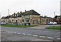
B4022 Hailey Road passes The Robin Hood
Image: © Stuart Logan
Taken: 15 Jul 2012
0.14 miles
2
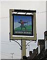
The Robin Hood (2) - sign, 81 Hailey Road, Witney
The pub is named after the famous medieval outlaw and folk hero, who may have lived in Sherwood Forest in Nottinghamshire, or possibly lived in Yorkshire. The pub has carried his name since at least 1939. Update November 2016:- the sign has been removed as the building ceased to be a pub a year or two ago.
Image
Image: © P L Chadwick
Taken: 19 Nov 2011
0.14 miles
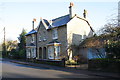
3
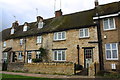
Houses on Hailey Road
There is an OS benchmark Image on a house wall stone on the left of the door of #81, above the metal gate
Image: © Roger Templeman
Taken: 10 Feb 2016
0.14 miles
4

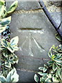
Benchmark on #81 Hailey Road
Ordnance Survey cut mark benchmark described on the Bench Mark Database at http://www.bench-marks.org.uk/bm37230
Image: © Roger Templeman
Taken: 5 Mar 2011
0.14 miles
5
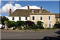
The Robin Hood (1), 81 Hailey Road, Witney
This pub is on the B4022 road, which here runs through a large estate of what is now called social housing. The pub is attached to a row of cottages, which appear to be much older. The pub itself has been here since at least 1939, as it appears in a Kelly's Trade Directory for that year under its present name. The rather ugly single storey section is probably later.
Update November 2016: - This public house closed a year or two ago. There was some talk of it becoming a restaurant but that didn't happen and it looks from the outside as if it has been turned into residential use.
Image
Image: © P L Chadwick
Taken: 19 Nov 2011
0.15 miles
6
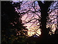
Winter sunset, Woodgreen, Witney
Taken shortly after 1700 from near outside the offices of West Oxfordshire District Council. The house roof is in Farmer's Close.
Image: © Brian Robert Marshall
Taken: 11 Dec 2006
0.15 miles
7
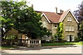
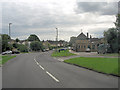
Council offices in Woodgreen
Witney Registry Office is in this building.
Image: © Steve Daniels
Taken: 18 Aug 2013
0.16 miles
8
Nos. 22 and 24 New Yatt Road
There is an OS benchmark Image on the near corner, right hand face, of the near house
Image: © Roger Templeman
Taken: 29 Dec 2014
0.16 miles
9
Benchmark on #22 New Yatt Road
Ordnance Survey cut mark benchmark described on the Bench Mark Database at http://www.bench-marks.org.uk/bm37180
Image: © Roger Templeman
Taken: 1 Mar 2011
0.16 miles