IMAGES TAKEN NEAR TO
Schofield Gardens, WITNEY, OX28 1JY
Introduction
This page details the photographs taken nearby to Schofield Gardens, OX28 1JY by members of the Geograph project.
The Geograph project started in 2005 with the aim of publishing, organising and preserving representative images for every square kilometre of Great Britain, Ireland and the Isle of Man.

There are currently over 7.5m images from over14,400 individuals and you can help contribute to the project by visiting https://www.geograph.org.uk
Image Map (Loading...)


Getting Data...Please wait
Leaflet Map data © OpenStreetMap
Images are licensed for reuse under creativecommons.org/licenses/by-sa/2.0
Notes
- Clicking on the map will re-center to the selected point.
- The higher the marker number, the further away the image location is from the centre of the postcode.
Image Listing (7 Images Found)
Images are licensed for reuse under creativecommons.org/licenses/by-sa/2.0
Image
Details
Distance
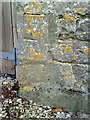
1
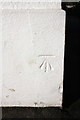
Benchmark on Witney Community Primary School
Ordnance Survey cut mark benchmark described on the Bench Mark Database at http://www.bench-marks.org.uk/bm73592
Image: © Roger Templeman
Taken: 18 Feb 2016
0.08 miles
2

The east wing of Witney Community Primary School
There is an OS benchmark Image on the near corner, left hand face, of the building
Image: © Roger Templeman
Taken: 18 Feb 2016
0.08 miles
3
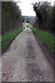
Milking Lane
This bridleway runs between Witney Road and Foxburrow Lane.
Image: © Roger Templeman
Taken: 5 Mar 2011
0.17 miles
4
Milestone beside B4022 opposite High Croft Farm
Milestone for Charlbury 6, Witney 1
Image: © Roger Templeman
Taken: 10 Feb 2016
0.23 miles
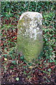
5

Old Milestone by the B4022, Hailey Road, north of Witney
Carved stone post by the B4022, in parish of HAILEY (WEST OXFORDSHIRE District), Hailey Road: 50m South of lane to Downhill Farm, between path and hedge, beside sign for horse riders, on Southwest side of road. Charlbury triangle, erected by the Charlbury Roads turnpike trust in the 19th century.
Inscription reads:-
: (Charlbury / 6) : : (Witney / 1) :
Oxfordshire HER.
HER Number: 10034 https://www.heritagegateway.org.uk/Gateway/Results_Single.aspx?uid=MOX2572&resourceID=1033
Milestone Society National ID: OX_WTGT01.
Image: © A Rosevear
Taken: 2 Jan 2004
0.23 miles
6
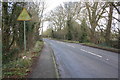
B4022 (Hailey Road) at High Croft Farm
There is an old milestone Image on the verge at the left foreground
Image: © Roger Templeman
Taken: 10 Feb 2016
0.23 miles
7
Benchmark on High Croft Farm
Ordnance Survey cut mark benchmark described on the Bench Mark Database at http://www.bench-marks.org.uk/bm37229
Image: © Roger Templeman
Taken: 5 Mar 2011
0.25 miles