IMAGES TAKEN NEAR TO
Crawley Road, WITNEY, OX28 1HX
Introduction
This page details the photographs taken nearby to Crawley Road, OX28 1HX by members of the Geograph project.
The Geograph project started in 2005 with the aim of publishing, organising and preserving representative images for every square kilometre of Great Britain, Ireland and the Isle of Man.

There are currently over 7.5m images from over14,400 individuals and you can help contribute to the project by visiting https://www.geograph.org.uk
Image Map (Loading...)


Getting Data...Please wait
Leaflet Map data © OpenStreetMap
Images are licensed for reuse under creativecommons.org/licenses/by-sa/2.0
Notes
- Clicking on the map will re-center to the selected point.
- The higher the marker number, the further away the image location is from the centre of the postcode.
Image Listing (17 Images Found)
Images are licensed for reuse under creativecommons.org/licenses/by-sa/2.0
Image
Details
Distance
1
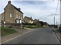
Crawley Road
Crawley Road heading to Witney
Image: © Shaun Ferguson
Taken: 9 Mar 2019
0.09 miles
2
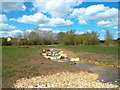
New Rocky Stream
Over the River Windrush from a new housing development this area of flat riverside meadow has been landscaped and a side stream opened up as a bit of a feature.
Image: © Des Blenkinsopp
Taken: 15 Apr 2012
0.10 miles
3
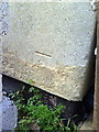
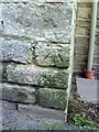
Benchmark on #41 Hailey Road
Ordnance Survey cut mark benchmark described on the Bench Mark Database at http://www.bench-marks.org.uk/bm37231
Image: © Roger Templeman
Taken: 5 Mar 2011
0.16 miles
4
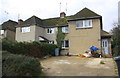
Nos. 39 and 41 Hailey Road
There is an OS benchmark Image on the front of the right hand house at its right hand corner on the concrete skirt below the pebbledash
Image: © Roger Templeman
Taken: 10 Feb 2016
0.16 miles
5
Benchmark on #8 Mount Pleasant, Witney Road
Ordnance Survey cut mark benchmark described on the Bench Mark Database at http://www.bench-marks.org.uk/bm37226
Image: © Roger Templeman
Taken: 5 Mar 2011
0.18 miles
6

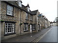
West End, Witney
This twisting section of the old street is at the other end from the section shown in Image "One of Britain's best preserved streets", according to http://en.wikipedia.org/wiki/Witney .
Image: © Derek Harper
Taken: 28 Jun 2008
0.18 miles
7
The House of Windsor pub, Witney
According to http://www.geograph.org.uk/photo/3833157 this pub has been closed since 2011
Image: © Bikeboy
Taken: 7 Apr 2014
0.21 miles
8
New and Old at Witney Mill
After the mill closed in 2002 new housing was built in the mill yard. Original mill buildings were converted at the same time giving the age mix seen here.
Image: © Des Blenkinsopp
Taken: 15 Apr 2012
0.22 miles
9
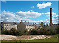
Old Mill - Woodford Mill, Witney
This was the last working blanket mill in Witney and closed in 2002. It has now been redeveloped for housing with the weaving sheds replaced by new houses. It is particularly satisfying to see that the chimney has been retained. This complex is shown on the site map as "Old Mill". The leat passes in front.
Image: © Chris Allen
Taken: 19 Aug 2017
0.22 miles
10
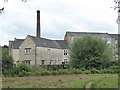
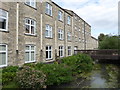
Former Woodford Mill, Witney
This was the last working blanket mill in Witney and closed in 2002. It has now been redeveloped for housing with the weaving sheds replaced by new houses. These buildings seen here are all part of the original complex and have been reused. It is particularly satisfying to see that the chimney has been retained.
Image: © Chris Allen
Taken: 19 Aug 2017
0.23 miles