IMAGES TAKEN NEAR TO
Bridge Street, WITNEY, OX28 1HD
Introduction
This page details the photographs taken nearby to Bridge Street, OX28 1HD by members of the Geograph project.
The Geograph project started in 2005 with the aim of publishing, organising and preserving representative images for every square kilometre of Great Britain, Ireland and the Isle of Man.

There are currently over 7.5m images from over14,400 individuals and you can help contribute to the project by visiting https://www.geograph.org.uk
Image Map (Loading...)


Getting Data...Please wait
Leaflet Map data © OpenStreetMap
Images are licensed for reuse under creativecommons.org/licenses/by-sa/2.0
Notes
- Clicking on the map will re-center to the selected point.
- The higher the marker number, the further away the image location is from the centre of the postcode.
Image Listing (88 Images Found)
Images are licensed for reuse under creativecommons.org/licenses/by-sa/2.0
Image
Details
Distance
1
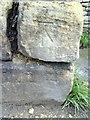
Benchmark on SE end of wall in front of Almshouses on Newland
Ordnance Survey cut mark benchmark described on the Bench Mark Database at http://www.bench-marks.org.uk/bm37172
Image: © Roger Templeman
Taken: 1 Mar 2011
0.03 miles
2
Milestone at B4022, A4095 crossroads
The milestone indicates 7 miles to Burford and 8 miles to Woodstock
Image: © Roger Templeman
Taken: 1 Mar 2011
0.04 miles
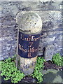
4

Old Milestone by the A4095, Woodgreen Hill, Witney parish
Metal plate attached to stone post by the A4095, in parish of WITNEY (WEST OXFORDSHIRE District), Woodgreen Hill; on mini-islands beside No.81, at junction with Newlands, against stone wall of house at back of pavement, on East side of road. Witney pillar and iron plate, erected by the Barrington & Campsfield turnpike trust in the 19th century.
Inscription reads:-
Burford
7
Woodſtock
8
Grade II listed.
List Entry Number: 1214101 https://historicengland.org.uk/listing/the-list/list-entry/1214101
Milestone Society National ID: OX_WSWT08
Image: © A Rosevear
Taken: 3 Dec 2002
0.04 miles
5
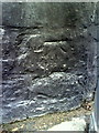
Benchmark on the Old Court Hotel, Bridge Street
Ordnance Survey cut mark benchmark described on the Bench Mark Database at http://www.bench-marks.org.uk/bm37171
Image: © Roger Templeman
Taken: 1 Mar 2011
0.04 miles
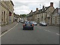
6
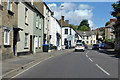
A4095 Bridge Street, Witney
The street bridges the Windrush behind the camera.
Image: © Robin Webster
Taken: 22 Aug 2020
0.04 miles
7
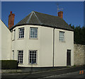
Old Toll House, Witney
Toll House by the A4095, in the parish of Witney, 47, West End, Woodgreen Hill, OX28 1NJ.
Surveyed
Milestone Society National ID: OX.WIT
Image: © Alan Rosevear
Taken: 23 Jan 2005
0.04 miles
8
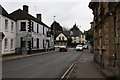
Old Court Hotel, Bridge Street
The roundabout is at the junction of Bridge Street (A4095) and the B4022 (West End left, Newland right)
Image: © Roger Templeman
Taken: 1 Mar 2011
0.05 miles
9
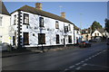
The Old Court Hotel, Bar & Restaurant, Bridge Street
There is an OS benchmark Image on the far corner of the pub
Image: © Roger Templeman
Taken: 29 Dec 2014
0.05 miles
10
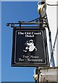
The Old Court Hotel (2) - sign, 39-43 Bridge Street, Witney, Oxon
The sign for the hotel.
Image
Image: © P L Chadwick
Taken: 30 May 2020
0.05 miles