IMAGES TAKEN NEAR TO
Bridge Street, WITNEY, OX28 1DA
Introduction
This page details the photographs taken nearby to Bridge Street, OX28 1DA by members of the Geograph project.
The Geograph project started in 2005 with the aim of publishing, organising and preserving representative images for every square kilometre of Great Britain, Ireland and the Isle of Man.

There are currently over 7.5m images from over14,400 individuals and you can help contribute to the project by visiting https://www.geograph.org.uk
Image Map
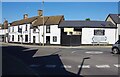
Images are licensed for reuse under creativecommons.org/licenses/by-sa/2.0
Notes
- Clicking on the map will re-center to the selected point.
- The higher the marker number, the further away the image location is from the centre of the postcode.
Image Listing (83 Images Found)
Images are licensed for reuse under creativecommons.org/licenses/by-sa/2.0
Image
Details
Distance
1
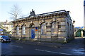
#28 Bridge Street, former government offices
There is an OS benchmark Image on the front face of the right hand corner of the building
Image: © Roger Templeman
Taken: 29 Dec 2014
0.01 miles
2
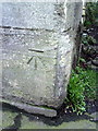
Benchmark on #28 Bridge Street
Ordnance Survey cut mark benchmark described on the Bench Mark Database at http://www.bench-marks.org.uk/bm37170
Image: © Roger Templeman
Taken: 1 Mar 2011
0.02 miles
3
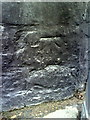
Benchmark on the Old Court Hotel, Bridge Street
Ordnance Survey cut mark benchmark described on the Bench Mark Database at http://www.bench-marks.org.uk/bm37171
Image: © Roger Templeman
Taken: 1 Mar 2011
0.03 miles
4
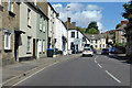
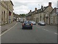
A4095 Bridge Street, Witney
The street bridges the Windrush behind the camera.
Image: © Robin Webster
Taken: 22 Aug 2020
0.03 miles
5
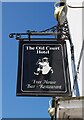
The Old Court Hotel (2) - sign, 39-43 Bridge Street, Witney, Oxon
The sign for the hotel.
Image
Image: © P L Chadwick
Taken: 30 May 2020
0.03 miles
6
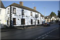
The Old Court Hotel, Bar & Restaurant, Bridge Street
There is an OS benchmark Image on the far corner of the pub
Image: © Roger Templeman
Taken: 29 Dec 2014
0.03 miles
7
Old Court Hotel, Bridge Street
The roundabout is at the junction of Bridge Street (A4095) and the B4022 (West End left, Newland right)
Image: © Roger Templeman
Taken: 1 Mar 2011
0.03 miles
9
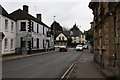
The Old Court Hotel (1), 39-43 Bridge Street, Witney, Oxon
This building was probably originally a coaching inn, as it has or had stables accessed through the gates in the middle. It was previously known as The Old Court Inn. Located on the corner of Bridge Street and West End, it is today a hotel with a bar and specialises in Nepalese food. The building dates from the 17th/18th century and was remodelled in the mid-19th century.
Image
Image: © P L Chadwick
Taken: 30 May 2020
0.04 miles
10
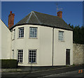
Old Toll House, Witney
Toll House by the A4095, in the parish of Witney, 47, West End, Woodgreen Hill, OX28 1NJ.
Surveyed
Milestone Society National ID: OX.WIT
Image: © Alan Rosevear
Taken: 23 Jan 2005
0.06 miles