IMAGES TAKEN NEAR TO
Marston Ferry Road, OXFORD, OX2 7WP
Introduction
This page details the photographs taken nearby to Marston Ferry Road, OX2 7WP by members of the Geograph project.
The Geograph project started in 2005 with the aim of publishing, organising and preserving representative images for every square kilometre of Great Britain, Ireland and the Isle of Man.

There are currently over 7.5m images from over14,400 individuals and you can help contribute to the project by visiting https://www.geograph.org.uk
Image Map
Images are licensed for reuse under creativecommons.org/licenses/by-sa/2.0
Notes
- Clicking on the map will re-center to the selected point.
- The higher the marker number, the further away the image location is from the centre of the postcode.
Image Listing (22 Images Found)
Images are licensed for reuse under creativecommons.org/licenses/by-sa/2.0
Image
Details
Distance

2

Where Oxford Road meets Cherwell Drive
Cherwell Drive is the major road, and Oxford Road joins it from the left. Despite the name, Oxford Road is a residential street which doesn't go anywhere.
Image: © Bill Boaden
Taken: 25 Jun 2010
0.15 miles

6
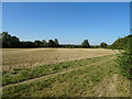
Stubble field, Old Marston
Off Marston Ferry Road (B4495).
Image: © JThomas
Taken: 21 Sep 2019
0.18 miles
7
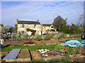
Overlooking the Allotments
These houses have a view over a large area of allotment land in the middle of the village.
Image: © Des Blenkinsopp
Taken: 6 Apr 2012
0.19 miles
8
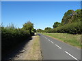
Cycle path beside Marston Ferry Road (B4495)
Image: © JThomas
Taken: 21 Sep 2019
0.19 miles
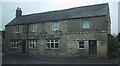
9
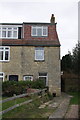
#61 Oxford Road ('Reborn Cottage')
There is an OS benchmark Image on the front corner above the side path
Image: © Roger Templeman
Taken: 7 Jan 2013
0.19 miles
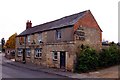
10
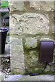
Benchmark on #61 Oxford Road
Ordnance Survey cut mark benchmark described on the Bench Mark Database at http://www.bench-marks.org.uk/bm46833
Image: © Roger Templeman
Taken: 7 Jan 2013
0.20 miles