IMAGES TAKEN NEAR TO
Banbury Road, OXFORD, OX2 7RR
Introduction
This page details the photographs taken nearby to Banbury Road, OX2 7RR by members of the Geograph project.
The Geograph project started in 2005 with the aim of publishing, organising and preserving representative images for every square kilometre of Great Britain, Ireland and the Isle of Man.

There are currently over 7.5m images from over14,400 individuals and you can help contribute to the project by visiting https://www.geograph.org.uk
Image Map
Images are licensed for reuse under creativecommons.org/licenses/by-sa/2.0
Notes
- Clicking on the map will re-center to the selected point.
- The higher the marker number, the further away the image location is from the centre of the postcode.
Image Listing (58 Images Found)
Images are licensed for reuse under creativecommons.org/licenses/by-sa/2.0
Image
Details
Distance
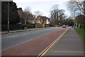
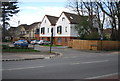
5
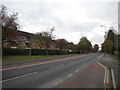
Banbury Road, Cutteslowe
Looking towards Oxford city centre from the northbound bus stop just south of Upland Park Road.
Image: © Richard Vince
Taken: 8 Nov 2016
0.06 miles
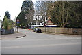
7
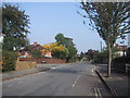
Southdale Road crosses Wentworth Road
Image: © Sarah Charlesworth
Taken: 8 Oct 2010
0.07 miles
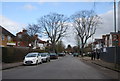
8
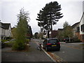
Upland Park Road, Cutteslowe
A residential cul de sac off Banbury Road.
Image: © Richard Vince
Taken: 8 Nov 2016
0.09 miles
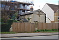
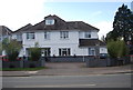
10
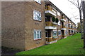
Block of flats on Banbury Road
There is an OS benchmark Image on the front side of the nearest apartment
Image: © Roger Templeman
Taken: 13 Nov 2012
0.09 miles