IMAGES TAKEN NEAR TO
Harpes Road, OXFORD, OX2 7QJ
Introduction
This page details the photographs taken nearby to Harpes Road, OX2 7QJ by members of the Geograph project.
The Geograph project started in 2005 with the aim of publishing, organising and preserving representative images for every square kilometre of Great Britain, Ireland and the Isle of Man.

There are currently over 7.5m images from over14,400 individuals and you can help contribute to the project by visiting https://www.geograph.org.uk
Image Map
Images are licensed for reuse under creativecommons.org/licenses/by-sa/2.0
Notes
- Clicking on the map will re-center to the selected point.
- The higher the marker number, the further away the image location is from the centre of the postcode.
Image Listing (33 Images Found)
Images are licensed for reuse under creativecommons.org/licenses/by-sa/2.0
Image
Details
Distance
1
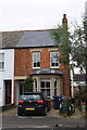
63A Islip Road
There is an OS benchmark Image on the side of the front right corner of the house which is at the east end of a row.
Image: © Roger Templeman
Taken: 7 Jan 2013
0.04 miles
2
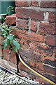
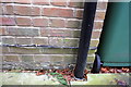
Benchmark on #63A Islip Road
Ordnance Survey cut mark benchmark described on the Bench Mark Database at http://www.bench-marks.org.uk/bm46823
Image: © Roger Templeman
Taken: 7 Jan 2013
0.04 miles
3
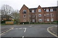
Junction of Water Eaton Road and Islip Road
Modern housing has replaced the Cherwell Hotel which used to occupy the site
Image: © Roger Templeman
Taken: 7 Jan 2013
0.09 miles

5
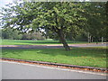
Cyclepath cuts the corner by Sunnymead Park
Image: © Sarah Charlesworth
Taken: 8 Oct 2010
0.14 miles
6
Benchmark on #12 Hernes Road
Ordnance Survey cut mark benchmark described on the Bench Mark Database at http://www.bench-marks.org.uk/bm46831
Image: © Roger Templeman
Taken: 7 Jan 2013
0.14 miles
7
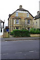
#10 and #12 Hernes Road
There is an OS benchmark Image on the side of the front corner of the left hand house of the semi-detached pair
Image: © Roger Templeman
Taken: 7 Jan 2013
0.14 miles
8
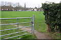
Entrance to Sunnymead Recreation Ground
There is an OS benchmark Image on the ivy-clad wooden post on the right hand side of the track
Image: © Roger Templeman
Taken: 7 Jan 2013
0.15 miles

10
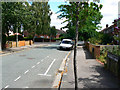
Looking east from Wentworth Road into Aldrich Road, Oxford
At virtually any time between December 1934 and 8th March 1959 this view wouldn't have been possible.
Note. This image has a detailed ‘shared description’ which you won’t see by viewing this image on a slideshow. To read it click on the image.
Image: © Brian Robert Marshall
Taken: 28 Jul 2010
0.16 miles