IMAGES TAKEN NEAR TO
Victoria Road, OXFORD, OX2 7QF
Introduction
This page details the photographs taken nearby to Victoria Road, OX2 7QF by members of the Geograph project.
The Geograph project started in 2005 with the aim of publishing, organising and preserving representative images for every square kilometre of Great Britain, Ireland and the Isle of Man.

There are currently over 7.5m images from over14,400 individuals and you can help contribute to the project by visiting https://www.geograph.org.uk
Image Map
Images are licensed for reuse under creativecommons.org/licenses/by-sa/2.0
Notes
- Clicking on the map will re-center to the selected point.
- The higher the marker number, the further away the image location is from the centre of the postcode.
Image Listing (59 Images Found)
Images are licensed for reuse under creativecommons.org/licenses/by-sa/2.0
Image
Details
Distance
1
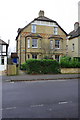
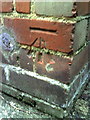
#10 and #12 Hernes Road
There is an OS benchmark Image on the side of the front corner of the left hand house of the semi-detached pair
Image: © Roger Templeman
Taken: 7 Jan 2013
0.07 miles
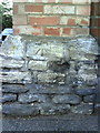
2
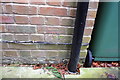
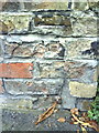
Benchmark on #12 Hernes Road
Ordnance Survey cut mark benchmark described on the Bench Mark Database at http://www.bench-marks.org.uk/bm46831
Image: © Roger Templeman
Taken: 7 Jan 2013
0.07 miles
5
Benchmark on #68 Hamilton Road
Ordnance Survey cut mark benchmark described on the Bench Mark Database at http://www.bench-marks.org.uk/bm32054
Image: © Roger Templeman
Taken: 13 Aug 2010
0.11 miles
6
Damaged benchmark on wall between #372 and #374 Banbury Road
Ordnance Survey cut mark benchmark described on the Bench Mark Database at http://www.bench-marks.org.uk/bm35217.
Image: © Roger Templeman
Taken: 13 Aug 2010
0.11 miles
9
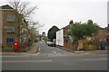
Hobson Road junction with Banbury Road
There is an OS benchmark Image on the corner wall pier on the right hand side of the junction (the boundary wall of #293 Banbury Road). The wall pier previously incorporated a letter box but has been rebuilt above the bottom section.
Image: © Roger Templeman
Taken: 7 Jan 2013
0.13 miles
10
Benchmark on wall pier at junction of Hobson Road and Banbury Road
Ordnance Survey cut mark benchmark described on the Bench Mark Database at http://www.bench-marks.org.uk/bm30425
Image: © Roger Templeman
Taken: 13 Aug 2010
0.13 miles