IMAGES TAKEN NEAR TO
Hamilton Road, OXFORD, OX2 7PZ
Introduction
This page details the photographs taken nearby to Hamilton Road, OX2 7PZ by members of the Geograph project.
The Geograph project started in 2005 with the aim of publishing, organising and preserving representative images for every square kilometre of Great Britain, Ireland and the Isle of Man.

There are currently over 7.5m images from over14,400 individuals and you can help contribute to the project by visiting https://www.geograph.org.uk
Image Map
Images are licensed for reuse under creativecommons.org/licenses/by-sa/2.0
Notes
- Clicking on the map will re-center to the selected point.
- The higher the marker number, the further away the image location is from the centre of the postcode.
Image Listing (74 Images Found)
Images are licensed for reuse under creativecommons.org/licenses/by-sa/2.0
Image
Details
Distance
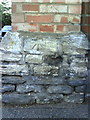
1
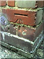
Benchmark on #68 Hamilton Road
Ordnance Survey cut mark benchmark described on the Bench Mark Database at http://www.bench-marks.org.uk/bm32054
Image: © Roger Templeman
Taken: 13 Aug 2010
0.08 miles
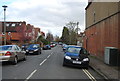
3
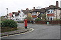
Junction of King's Cross Road and Portland Road
There is an OS benchmark Image on the straight section of the brick at its junction with the curved section on the corner. The pillar box is GR.
Image: © Roger Templeman
Taken: 7 Jan 2013
0.09 miles
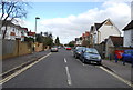
4
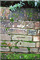
Benchmark on wall of #44 King's Cross Road
Ordnance Survey cut mark benchmark described on the Bench Mark Database at http://www.bench-marks.org.uk/bm46794
Image: © Roger Templeman
Taken: 7 Jan 2013
0.09 miles
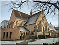
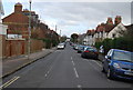
9
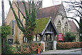
St Michael and All Angels Church
St Michael and All Angels Church on Lonsdale Road Summertown
Image: © Shaun Ferguson
Taken: 15 Mar 2008
0.11 miles
10
Benchmark on wall pier at junction of Hobson Road and Banbury Road
Ordnance Survey cut mark benchmark described on the Bench Mark Database at http://www.bench-marks.org.uk/bm30425
Image: © Roger Templeman
Taken: 13 Aug 2010
0.11 miles