IMAGES TAKEN NEAR TO
Woodstock Road, OXFORD, OX2 7PA
Introduction
This page details the photographs taken nearby to Woodstock Road, OX2 7PA by members of the Geograph project.
The Geograph project started in 2005 with the aim of publishing, organising and preserving representative images for every square kilometre of Great Britain, Ireland and the Isle of Man.

There are currently over 7.5m images from over14,400 individuals and you can help contribute to the project by visiting https://www.geograph.org.uk
Image Map
Images are licensed for reuse under creativecommons.org/licenses/by-sa/2.0
Notes
- Clicking on the map will re-center to the selected point.
- The higher the marker number, the further away the image location is from the centre of the postcode.
Image Listing (63 Images Found)
Images are licensed for reuse under creativecommons.org/licenses/by-sa/2.0
Image
Details
Distance
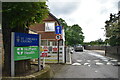
1
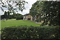
Oxford : St John's College Sports Ground
Looking towards the sports ground from Woodstock Road.
Image: © Lewis Clarke
Taken: 29 Jun 2014
0.04 miles
2
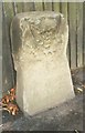
Old Boundary Marker by the A4144, Woodstock Road, Oxford Parish
Parish Boundary Marker by the A4144, in parish of Oxford (Oxford District), Woodstock Road; opposite Playground, on path by fence bordering King Edward School playing fields, West side of road.
Surveyed
Milestone Society National ID: OX_LW56pb
Image: © Milestone Society
Taken: Unknown
0.05 miles
6
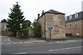
#276 Woodstock Road - a boarded up house
There is an OS benchmark Image on the front left corner. The red notice is for Riach Architects who are presumably charged with designing the refurbishment.
Image: © Roger Templeman
Taken: 9 Sep 2011
0.07 miles
7
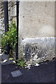
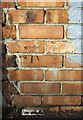
Benchmark on #276 Woodstock Road
Ordnance Survey cut mark benchmark described on the Bench Mark Database at http://www.bench-marks.org.uk/bm28708
Image: © Roger Templeman
Taken: 9 Sep 2011
0.07 miles
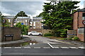
9
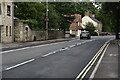
Junction of Woodstock Road and South Parade
There is an OS benchmark Image on the wall at the junction of the house and the wall on its right hand side. It is believed that there was a boundary stone on the corner in the 1850s, http://www.bench-marks.org.uk/bm20000
Image: © Roger Templeman
Taken: 21 Dec 2012
0.08 miles
10
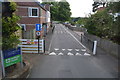
Benchmark on #254 Woodstock Road (South Parade face)
Ordnance Survey cut mark benchmark described on the Bench Mark Database at http://www.bench-marks.org.uk/bm28733
Image: © Roger Templeman
Taken: 21 Dec 2012
0.08 miles