IMAGES TAKEN NEAR TO
Woodstock Road, OXFORD, OX2 7NB
Introduction
This page details the photographs taken nearby to Woodstock Road, OX2 7NB by members of the Geograph project.
The Geograph project started in 2005 with the aim of publishing, organising and preserving representative images for every square kilometre of Great Britain, Ireland and the Isle of Man.

There are currently over 7.5m images from over14,400 individuals and you can help contribute to the project by visiting https://www.geograph.org.uk
Image Map
Images are licensed for reuse under creativecommons.org/licenses/by-sa/2.0
Notes
- Clicking on the map will re-center to the selected point.
- The higher the marker number, the further away the image location is from the centre of the postcode.
Image Listing (141 Images Found)
Images are licensed for reuse under creativecommons.org/licenses/by-sa/2.0
Image
Details
Distance
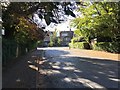
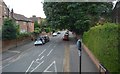
1
Woodstock Road, approaching Staverton Road
Image: © David Smith
Taken: 29 Dec 2011
0.02 miles
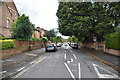
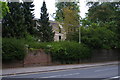
7
Woodstock Road, Oxford: University College annexe
The annexe, whose entrance lies on Staverton Road, houses third-year undergraduates and postgraduate students.
Image: © Christopher Hilton
Taken: 4 May 2017
0.03 miles
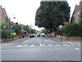
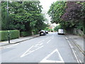
8
Woodstock Road, Oxford: University College annexe
The entrance to the annexe, which houses third year undergraduates and postgraduates, is on Staverton Road.
Image: © Christopher Hilton
Taken: 4 May 2017
0.04 miles