IMAGES TAKEN NEAR TO
South Parade, OXFORD, OX2 7JN
Introduction
This page details the photographs taken nearby to South Parade, OX2 7JN by members of the Geograph project.
The Geograph project started in 2005 with the aim of publishing, organising and preserving representative images for every square kilometre of Great Britain, Ireland and the Isle of Man.

There are currently over 7.5m images from over14,400 individuals and you can help contribute to the project by visiting https://www.geograph.org.uk
Image Map
Images are licensed for reuse under creativecommons.org/licenses/by-sa/2.0
Notes
- Clicking on the map will re-center to the selected point.
- The higher the marker number, the further away the image location is from the centre of the postcode.
Image Listing (118 Images Found)
Images are licensed for reuse under creativecommons.org/licenses/by-sa/2.0
Image
Details
Distance
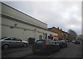
1
Middle Way at the junction of South Parade
Image: © David Howard
Taken: 21 Feb 2016
0.02 miles
2
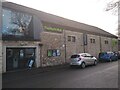
North Wall arts centre
Arts centre on South Parade.
Image: © Pierre Marshall
Taken: 17 Dec 2020
0.05 miles
3

North Wall arts centre
Arts centre on South Parade.
Image: © Pierre Marshall
Taken: 17 Dec 2020
0.05 miles
4
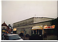
Ristorante Pizzeria 1899
1899 is the date on the panel above the window. Now an Italian restaurant, might this building have been a fire station at one time? It's got that sort of look.
Image: © Des Blenkinsopp
Taken: 26 Jun 2012
0.06 miles
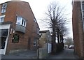
5

Citroen & Spiritualist Church
Old and new buildings in Middle Way, Summertown.
Image: © Des Blenkinsopp
Taken: 26 Jun 2012
0.06 miles
6

St Edward's School, Summertown, Oxford
St Edward’s School was founded in 1863 by the Rev. Thomas Chamberlain, student of Christ Church, Vicar of St Thomas the Martyr. The original school building was Mackworth Hall, which then stood on New Inn Hall Street in central Oxford. In 1873, after a storm had damaged the school buildings and in anticipation of growing numbers, the Rev. A. B. Simeon, first Warden, moved the school to Summertown. At the time, the site was on the boundary of Oxford and surrounded by farmland, and Rev. Simeon bought a large plot for the school. At the end of WW 2 the school was presented with a stained glass window by the R.A.F. in recognition of “the superb contribution to the war effort made by former pupils of the School”. These included, among many others, Wing Commander Guy Gibson VC DSO DFC of 617 Squadron, who led 'The Dambusters', flying ace Group Captain Sir Douglas Bader DSO DFC, and Adrian Warburton DSO & Bar DFC& Two Bar, famous for his role in the defence of Malta. Pacifist inclinations during the 1970s and 1980s caused the window to be relocated, but it can now be found back on display in the Old Library.
Image: © Len Williams
Taken: 20 Feb 2011
0.07 miles
7
South Parade, Summertown
Compare with a view I took in 1988 http://www.geograph.org.uk/photo/4837626
Image: © David Howard
Taken: 21 Feb 2016
0.07 miles
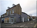
9
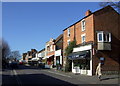
South Parade
Summertown's 'village street' of mainly small shops, restaurants and other neighbourhood facilities. It is said the name derives from the fact of its being the southernmost parade ground for the Parliamentary army during the Civil War, in contrast to the Royalists' northern parade further down the Banbury Road - but this may be apocryphal.
Image: © Natasha Ceridwen de Chroustchoff
Taken: 4 Mar 2008
0.08 miles