IMAGES TAKEN NEAR TO
Marston Ferry Road, OXFORD, OX2 7EF
Introduction
This page details the photographs taken nearby to Marston Ferry Road, OX2 7EF by members of the Geograph project.
The Geograph project started in 2005 with the aim of publishing, organising and preserving representative images for every square kilometre of Great Britain, Ireland and the Isle of Man.

There are currently over 7.5m images from over14,400 individuals and you can help contribute to the project by visiting https://www.geograph.org.uk
Image Map
Images are licensed for reuse under creativecommons.org/licenses/by-sa/2.0
Notes
- Clicking on the map will re-center to the selected point.
- The higher the marker number, the further away the image location is from the centre of the postcode.
Image Listing (74 Images Found)
Images are licensed for reuse under creativecommons.org/licenses/by-sa/2.0
Image
Details
Distance
1
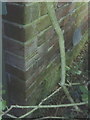
Benchmark on side of #12 Marston Ferry Road
Rather dim photograph of Ordnance Survey cut mark benchmark in shade and behind a bush, with the cuts on the corners of the 4th and 5th bricks down from top of photograph. The mark is described on the Bench Mark Database at http://www.bench-marks.org.uk/bm35215.
Image: © Roger Templeman
Taken: 13 Aug 2010
0.04 miles
2
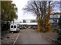
Oxford High School
Oxford High School is one of the leading girls' schools in the country, with an outstanding academic record. The postal address of the school is Belbroughton Road, but the main entrance is just around the corner in Charlbury Road.
The untidy clump of beech on the right is in fact several trees which have been allowed to grow much too close together.
Image: © Dr Neil Clifton
Taken: 15 Nov 2008
0.09 miles
4
Oxford High School
It appears to be undergoing a major reconstruction, presumably linked to Building Schools for the Future.
Image: © Bill Boaden
Taken: 6 Mar 2010
0.11 miles
5
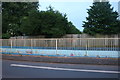
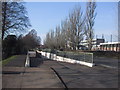
Subway along Marston Ferry Road, Summertown
Image: © David Howard
Taken: 23 May 2020
0.11 miles
6
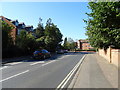
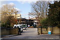
Marston Ferry Road (B4495), Oxford
Approaching Banbury Road.
Image: © JThomas
Taken: 21 Sep 2019
0.12 miles
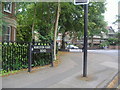
8
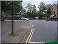
Junction of Marston Ferry Road and Banbury Road
Image: © David Howard
Taken: 29 Jun 2011
0.13 miles
9
Underpass for pedestrians and cyclists
Image: © Sarah Charlesworth
Taken: 31 Jan 2011
0.14 miles
10
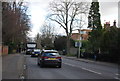
Corner of Marston Ferry Road and Banbury Road
Image: © David Howard
Taken: 29 Jun 2011
0.14 miles