IMAGES TAKEN NEAR TO
Lark Hill, OXFORD, OX2 7DR
Introduction
This page details the photographs taken nearby to Lark Hill, OX2 7DR by members of the Geograph project.
The Geograph project started in 2005 with the aim of publishing, organising and preserving representative images for every square kilometre of Great Britain, Ireland and the Isle of Man.

There are currently over 7.5m images from over14,400 individuals and you can help contribute to the project by visiting https://www.geograph.org.uk
Image Map
Images are licensed for reuse under creativecommons.org/licenses/by-sa/2.0
Notes
- Clicking on the map will re-center to the selected point.
- The higher the marker number, the further away the image location is from the centre of the postcode.
Image Listing (78 Images Found)
Images are licensed for reuse under creativecommons.org/licenses/by-sa/2.0
Image
Details
Distance
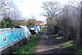
2
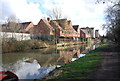
Community litter-picking at Waterways
This was the centre of operations.
Image: © Bill Boaden
Taken: 6 Mar 2010
0.07 miles
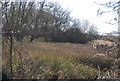
4
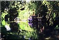
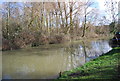
Oxford Canal
A sleepy spot, only a short distance to the west of the busy Woodstock Road.
Image: © Rosalind Mitchell
Taken: Unknown
0.08 miles
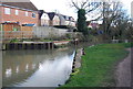
5
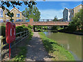
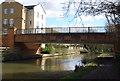
Bridge 238B: Elizabeth Jennings Way Bridge
Crossing the Oxford Canal in Oxford.
Image: © Mat Fascione
Taken: 15 Jun 2015
0.09 miles