IMAGES TAKEN NEAR TO
Cunliffe Close, OXFORD, OX2 7BJ
Introduction
This page details the photographs taken nearby to Cunliffe Close, OX2 7BJ by members of the Geograph project.
The Geograph project started in 2005 with the aim of publishing, organising and preserving representative images for every square kilometre of Great Britain, Ireland and the Isle of Man.

There are currently over 7.5m images from over14,400 individuals and you can help contribute to the project by visiting https://www.geograph.org.uk
Image Map
Images are licensed for reuse under creativecommons.org/licenses/by-sa/2.0
Notes
- Clicking on the map will re-center to the selected point.
- The higher the marker number, the further away the image location is from the centre of the postcode.
Image Listing (94 Images Found)
Images are licensed for reuse under creativecommons.org/licenses/by-sa/2.0
Image
Details
Distance
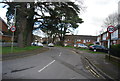
6
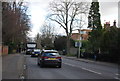
New houses on Banbury Road, Summertown
Designed to match the existing Victorian houses
Image: © David Howard
Taken: 21 Feb 2016
0.08 miles
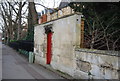
7
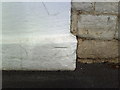
Painted over benchmark on North Lodge
Ordnance Survey cut mark benchmark described on the Bench Mark Database at http://www.bench-marks.org.uk/bm30535.
Image: © Roger Templeman
Taken: 13 Aug 2010
0.08 miles
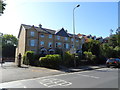
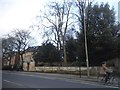
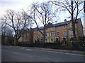
8
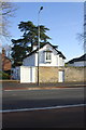
The North Lodge, Banbury Road
There is an OS benchmark Image at the base of the white wall pier left of the lamp post
Image: © Roger Templeman
Taken: 21 Dec 2012
0.08 miles
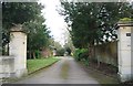
9
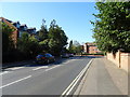
Marston Ferry Road (B4495), Oxford
Approaching Banbury Road.
Image: © JThomas
Taken: 21 Sep 2019
0.08 miles