IMAGES TAKEN NEAR TO
Lathbury Road, OXFORD, OX2 7AT
Introduction
This page details the photographs taken nearby to Lathbury Road, OX2 7AT by members of the Geograph project.
The Geograph project started in 2005 with the aim of publishing, organising and preserving representative images for every square kilometre of Great Britain, Ireland and the Isle of Man.

There are currently over 7.5m images from over14,400 individuals and you can help contribute to the project by visiting https://www.geograph.org.uk
Image Map
Images are licensed for reuse under creativecommons.org/licenses/by-sa/2.0
Notes
- Clicking on the map will re-center to the selected point.
- The higher the marker number, the further away the image location is from the centre of the postcode.
Image Listing (109 Images Found)
Images are licensed for reuse under creativecommons.org/licenses/by-sa/2.0
Image
Details
Distance
1

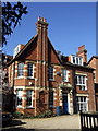
Houses on Staverton Road, Oxford
Some of the large North Oxford houses that date from the city's late 19th-century expansion, when dons for the first time were allowed to marry and live outside their colleges.
Image: © Christopher Hilton
Taken: 4 May 2017
0.05 miles
2
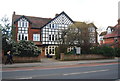
North Oxford house, Banbury Road
This house, dated 1910, on the west side of the road, is typical of the huge residences built for Oxford dons (professors), their families and servants during the second half of the C19 and after. It now forms part of an educational institution.
Image: © Natasha Ceridwen de Chroustchoff
Taken: 4 Mar 2008
0.06 miles
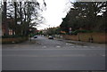
7

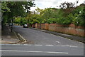
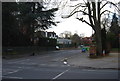
Oxford : Woodstock Road A4144
Looking along Woodstock Road as it heads into Oxford.
Image: © Lewis Clarke
Taken: 29 Jun 2014
0.08 miles
9
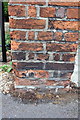
Benchmark on the gatepost of #215 Woodstock Road
Ordnance Survey cut mark benchmark described on the Bench Mark Database at http://www.bench-marks.org.uk/bm28726
Image: © Roger Templeman
Taken: 9 Sep 2011
0.09 miles
10
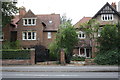
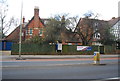
#215 and #217 Woodstock Road
There is an OS benchmark Image on the gatepost in the middle of the picture.
Image: © Roger Templeman
Taken: 9 Sep 2011
0.09 miles