IMAGES TAKEN NEAR TO
Main Street, BICESTER, OX27 9BB
Introduction
This page details the photographs taken nearby to Main Street, OX27 9BB by members of the Geograph project.
The Geograph project started in 2005 with the aim of publishing, organising and preserving representative images for every square kilometre of Great Britain, Ireland and the Isle of Man.

There are currently over 7.5m images from over14,400 individuals and you can help contribute to the project by visiting https://www.geograph.org.uk
Image Map (Loading...)


Getting Data...Please wait
Leaflet Map data © OpenStreetMap
Images are licensed for reuse under creativecommons.org/licenses/by-sa/2.0
Notes
- Clicking on the map will re-center to the selected point.
- The higher the marker number, the further away the image location is from the centre of the postcode.
Image Listing (12 Images Found)
Images are licensed for reuse under creativecommons.org/licenses/by-sa/2.0
Image
Details
Distance
2
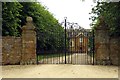
The gates to Poundon House
Poundon House is run as a wedding venue.
Image: © Steve Daniels
Taken: 1 Jul 2014
0.07 miles
3
Poundon House, Poundon
A grade II listed building, foundation stone dated 1908.
Image: © Robin Webster
Taken: 22 Feb 2014
0.12 miles
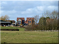
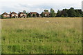
4

Poundon House
From the Bernwood Way looking across to Poundon House
Image: © Shaun Ferguson
Taken: 8 Jun 2007
0.12 miles
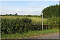
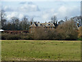
6
Houses, Poundon
Viewed from the back across the fields. The near field shows signs of old ridge and furrow cultivation.
Image: © Robin Webster
Taken: 22 Feb 2014
0.17 miles

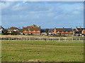
8

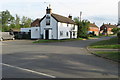
The Sow & Pigs in Poundon
The Sow & Pigs is a Brakspear tied pub.
Image: © Steve Daniels
Taken: 1 Jul 2014
0.21 miles