IMAGES TAKEN NEAR TO
Church Street, BICESTER, OX27 0ET
Introduction
This page details the photographs taken nearby to Church Street, OX27 0ET by members of the Geograph project.
The Geograph project started in 2005 with the aim of publishing, organising and preserving representative images for every square kilometre of Great Britain, Ireland and the Isle of Man.

There are currently over 7.5m images from over14,400 individuals and you can help contribute to the project by visiting https://www.geograph.org.uk
Image Map (Loading...)


Getting Data...Please wait
Leaflet Map data © OpenStreetMap
Images are licensed for reuse under creativecommons.org/licenses/by-sa/2.0
Notes
- Clicking on the map will re-center to the selected point.
- The higher the marker number, the further away the image location is from the centre of the postcode.
Image Listing (34 Images Found)
Images are licensed for reuse under creativecommons.org/licenses/by-sa/2.0
Image
Details
Distance
1
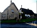
Cottages on Church Street, Marsh Gibbon
Image: © David Howard
Taken: 13 Jun 2020
0.04 miles
2
Cottage on Church Street, Marsh Gibbon
Image: © David Howard
Taken: 13 Jun 2020
0.04 miles
3
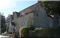
Thatched buildings in Marsh Gibbon
The building on the left is Middle Farmhouse, built in C17 and the one on the rights is Forge House also C17. See http://www.britishlistedbuildings.co.uk/en-399469-middle-farmhouse-marsh-gibbon-buckingham and http://www.britishlistedbuildings.co.uk/en-399467-forge-house-marsh-gibbon-buckinghamshire for entries in British Listed Buildings
Image: © Bikeboy
Taken: 1 Nov 2014
0.06 miles
4
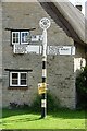
Direction Sign - Signpost in Marsh Gibbon
Annulus finial - 3 arms; Bucks. County halo by the UC road, in parish of Marsh Gibbon (Aylesbury Vale District), junction of Church Street with Clements Lane.
Surveyed
Milestone Society National ID: BU_SP6423
Image: © John V Nicholls
Taken: 31 Aug 2014
0.06 miles
5
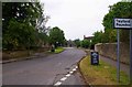
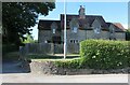
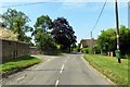
Church Street, Marsh Gibbon, Bucks
The road turning off to the left, in the distance, is Clements Lane along which the village hall is located.
Image: © P L Chadwick
Taken: 20 Jul 2014
0.07 miles
7
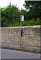
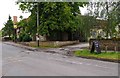
Bus stop in Church Street, Marsh Gibbon, Bucks
Marsh Gibbon is better off than many villages in that there are a few buses Monday to Saturday which serve the village. Marsh Gibbon and Poundon Railway Station, which was some way from the village, saw its last passengers on the 30th December 1967.
Image: © P L Chadwick
Taken: 20 Jul 2014
0.09 miles
9
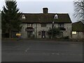
The Plough (3), Church Street, Marsh Gibbon, Bucks
Looking at the public house from this direction, a lot of it is obscured by trees and bushes unfortunately.
Image
Image
Image: © P L Chadwick
Taken: 20 Jul 2014
0.10 miles