IMAGES TAKEN NEAR TO
Heet Road, BICESTER, OX27 0AJ
Introduction
This page details the photographs taken nearby to Heet Road, OX27 0AJ by members of the Geograph project.
The Geograph project started in 2005 with the aim of publishing, organising and preserving representative images for every square kilometre of Great Britain, Ireland and the Isle of Man.

There are currently over 7.5m images from over14,400 individuals and you can help contribute to the project by visiting https://www.geograph.org.uk
Image Map
Images are licensed for reuse under creativecommons.org/licenses/by-sa/2.0
Notes
- Clicking on the map will re-center to the selected point.
- The higher the marker number, the further away the image location is from the centre of the postcode.
Image Listing (3 Images Found)
Images are licensed for reuse under creativecommons.org/licenses/by-sa/2.0
Image
Details
Distance
1
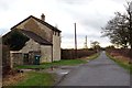
A rural road passes Grange Farm
The road runs from Marsh Gibbon to Piddington.
Image: © Steve Daniels
Taken: 13 Jan 2015
0.01 miles
2
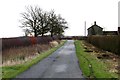
Rural road to Marsh Gibbon
The Bernwood Jubilee Way walks along this road then crosses fields just past Grange Farm on the right to Ludgershall.
Image: © Steve Daniels
Taken: 13 Jan 2015
0.11 miles
3
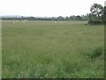
Bernwood Jubilee Way footpath
Although there is no apparent route through the grass, the Bernwood Jubilee Way footpath does cross this field.
Image: © David Luther Thomas
Taken: 16 Jun 2007
0.12 miles