IMAGES TAKEN NEAR TO
Blackthorn Road, BICESTER, OX27 0AG
Introduction
This page details the photographs taken nearby to Blackthorn Road, OX27 0AG by members of the Geograph project.
The Geograph project started in 2005 with the aim of publishing, organising and preserving representative images for every square kilometre of Great Britain, Ireland and the Isle of Man.

There are currently over 7.5m images from over14,400 individuals and you can help contribute to the project by visiting https://www.geograph.org.uk
Image Map
Images are licensed for reuse under creativecommons.org/licenses/by-sa/2.0
Notes
- Clicking on the map will re-center to the selected point.
- The higher the marker number, the further away the image location is from the centre of the postcode.
Image Listing (6 Images Found)
Images are licensed for reuse under creativecommons.org/licenses/by-sa/2.0
Image
Details
Distance
1
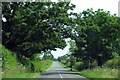
The road to Marsh Gibbon passes the Leverets
Image: © Steve Daniels
Taken: 23 Jun 2014
0.02 miles
3
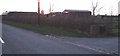
Farm buildings at sunset
These farm buildings are just a little south-west of Image I've marked this as a supplemental image due to the lack of detail.
Image: © Rob Farrow
Taken: 2 Jan 2007
0.11 miles
4
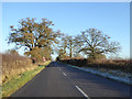
Road to Marsh Gibbon
Entering Buckinghamshire from Oxfordshire.
Image: © Robin Webster
Taken: 4 Dec 2016
0.12 miles
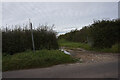
5
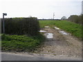
Bridleway to Launton
From the road the bridleway to Launton
Image: © Shaun Ferguson
Taken: 10 Apr 2010
0.14 miles
6
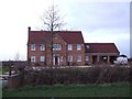
New farmhouse
This would appear to be a recently built large farmhouse southwest of Marsh Gibbon. It is not named on the map, being probably too new. It is slightly to the NE of the dwelling marked as Leverets and is on the opposite side of the road. The Image] would seem to be associated with it.
Image: © Rob Farrow
Taken: 2 Jan 2007
0.18 miles