IMAGES TAKEN NEAR TO
Hayfield Road, OXFORD, OX2 6TX
Introduction
This page details the photographs taken nearby to Hayfield Road, OX2 6TX by members of the Geograph project.
The Geograph project started in 2005 with the aim of publishing, organising and preserving representative images for every square kilometre of Great Britain, Ireland and the Isle of Man.

There are currently over 7.5m images from over14,400 individuals and you can help contribute to the project by visiting https://www.geograph.org.uk
Image Map
Images are licensed for reuse under creativecommons.org/licenses/by-sa/2.0
Notes
- Clicking on the map will re-center to the selected point.
- The higher the marker number, the further away the image location is from the centre of the postcode.
Image Listing (133 Images Found)
Images are licensed for reuse under creativecommons.org/licenses/by-sa/2.0
Image
Details
Distance
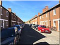
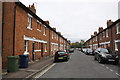
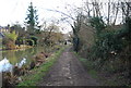
1
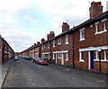
North along Hayfield Road, Oxford
Looking towards Frenchay Road in the north of Oxford.
Image: © Jaggery
Taken: 31 Mar 2013
0.01 miles
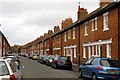
4
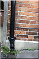
Benchmark on #38 Hayfield Road
Ordnance Survey cut mark benchmark described on the Bench Mark Database at http://www.bench-marks.org.uk/bm32090
Image: © Roger Templeman
Taken: 9 Sep 2011
0.02 miles
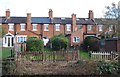
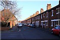
5
Hayfield Road
There is an OS benchmark Image on the front of the first house on the left
Image: © Roger Templeman
Taken: 9 Sep 2011
0.02 miles
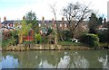
10
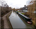
Narrowboats on the Oxford Canal
Moored north of Aristotle Bridge. http://www.geograph.org.uk/photo/4091063
Image: © Jaggery
Taken: 31 Mar 2013
0.05 miles