IMAGES TAKEN NEAR TO
Polstead Road, OXFORD, OX2 6TW
Introduction
This page details the photographs taken nearby to Polstead Road, OX2 6TW by members of the Geograph project.
The Geograph project started in 2005 with the aim of publishing, organising and preserving representative images for every square kilometre of Great Britain, Ireland and the Isle of Man.

There are currently over 7.5m images from over14,400 individuals and you can help contribute to the project by visiting https://www.geograph.org.uk
Image Map
Images are licensed for reuse under creativecommons.org/licenses/by-sa/2.0
Notes
- Clicking on the map will re-center to the selected point.
- The higher the marker number, the further away the image location is from the centre of the postcode.
Image Listing (134 Images Found)
Images are licensed for reuse under creativecommons.org/licenses/by-sa/2.0
Image
Details
Distance
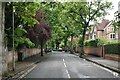
1
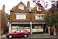
West along Polstead Road, Oxford
This is the road Lawrence of Arabia lived in as a youngster from 1896. More here http://www.geograph.org.uk/photo/1984429
Image: © Brian Robert Marshall
Taken: 28 Jul 2010
0.02 miles
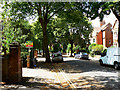
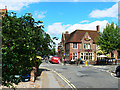
2

No entry to Polstead Road, Oxford
Viewed from near The Anchor pub. http://www.geograph.org.uk/photo/4090919
Image: © Jaggery
Taken: 31 Mar 2013
0.04 miles
3
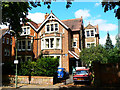
2 Polstead Road, Oxford
Otherwise just another substantial semi-detached Victorian villa, 2 Polstead Road is notable for being the childhood home of Colonel T E Lawrence, also known as Lawrence of Arabia, John Hume Ross and T E Shaw. He moved here with his parents in 1896 when he was about eight. His parents, who weren't married to each other, lived here until 1921 bringing up five sons of whom T E was the second oldest. The house has been graced with a blue plaque commemorating Lawrence's association with the property http://www.geograph.org.uk/photo/1984434 He lived in this cottage in Dorset until his death in a motorcycle accident on his way back to it http://www.geograph.org.uk/photo/587816
Image: © Brian Robert Marshall
Taken: 28 Jul 2010
0.05 miles
4
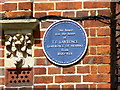
Blue plaque, 2 Polstead Road, Oxford
The plaque commemorating Lawrence of Arabia's association with the villa to which is attached can be seen in context here http://www.geograph.org.uk/photo/1984429 with a bit more about the property.
Image: © Brian Robert Marshall
Taken: 28 Jul 2010
0.05 miles
5
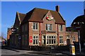
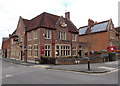
The Anchor in Hayfield Road
This pub has been known locally as the Dolly's Hut for decades.
Image: © Steve Daniels
Taken: 13 Mar 2010
0.05 miles
6
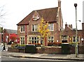
The Anchor
At the corner of Hayfield and Polstead Roads. 1930s-built pub, now noted for its food http://www.theanchoroxford.com/ .
Image: © Rose and Trev Clough
Taken: 30 Oct 2011
0.06 miles
8
Kingston Road, Oxford
Kingston Road is in the foreground. At the right is the junction with Polstead Road. The pub on the corner is the Anchor Inn in Hayfield Road. The Anchor features in one of the Inspector Morse crime stories 'Death is Now My Neighbour' although whether it was in the original novel by Colin Dexter or the ITV 'Morse' episode of the same name or both I can't recall. I do remember the identity of the murderer though. It was
Image: © Brian Robert Marshall
Taken: 28 Jul 2010
0.07 miles
9
The Anchor, Oxford
Pub at 2 Hayfield Road, on the corner of Polstead Road.
Image: © Jaggery
Taken: 31 Mar 2013
0.07 miles