IMAGES TAKEN NEAR TO
Bardwell Road, OXFORD, OX2 6SR
Introduction
This page details the photographs taken nearby to Bardwell Road, OX2 6SR by members of the Geograph project.
The Geograph project started in 2005 with the aim of publishing, organising and preserving representative images for every square kilometre of Great Britain, Ireland and the Isle of Man.

There are currently over 7.5m images from over14,400 individuals and you can help contribute to the project by visiting https://www.geograph.org.uk
Image Map
Images are licensed for reuse under creativecommons.org/licenses/by-sa/2.0
Notes
- Clicking on the map will re-center to the selected point.
- The higher the marker number, the further away the image location is from the centre of the postcode.
Image Listing (104 Images Found)
Images are licensed for reuse under creativecommons.org/licenses/by-sa/2.0
Image
Details
Distance
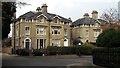
1

Benchmark on electricity substation wall, Dragon Lane
Ordnance Survey cut mark benchmark described on the Bench Mark Database at http://www.bench-marks.org.uk/bm22283
Image: © Roger Templeman
Taken: 30 Jan 2012
0.04 miles
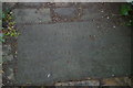
2
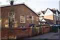
Electricity substation, Park Town Nursery and Dragon School
There is an OS benchmark Image on the wall of the electricity substation to the left of the wheelie bin
Image: © Roger Templeman
Taken: 30 Jan 2012
0.04 miles
3
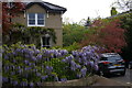
Park Town, North Oxford
In early May Oxford's walls and quadrangles are very often draped with wisteria flowers: the city has a large number of mature plants.
Image: © Christopher Hilton
Taken: 4 May 2017
0.05 miles
4
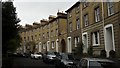
The Terrace, Park Town
The stone-fronted terraces around the garden recall Cheltenham; the yellow brick here is more like Cambridge or Bedford. Most of the backs of Park Town houses are of red brick.
Image: © Chris Brown
Taken: 13 Nov 2017
0.06 miles
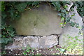
5
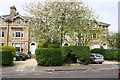
Houses on Park Town: Nos. 35, 37 and 39
There is an OS benchmark Image on a stone in the low wall below the junction of hedges in the middle of the image
Image: © Roger Templeman
Taken: 12 Apr 2014
0.06 miles
7
Memorial plaque to the ecologist Charles Elton, Park Town, Oxford
Scarcely readable, this plaque commemorates the fact that the small gardens at the east end of Park Town were cared for by the ecologist and zoologist Charles Elton (1900-1991): see https://en.wikipedia.org/wiki/Charles_Sutherland_Elton for details.
To see the plaque in context, go to Image
Image: © Christopher Hilton
Taken: 5 May 2017
0.06 miles
8
Benchmark on wall between #35 and #37 Park Town
Ordnance Survey cut mark benchmark described on the Bench Mark Database at http://www.bench-marks.org.uk/bm31913
Image: © Roger Templeman
Taken: 12 Apr 2014
0.06 miles
9
Path through gardens, Park Town, Oxford
This path cuts through the small garden set at the centre of Park Town's eastern crescent.
Visible at the bottom of the picture, the memorial plaque to the ecologist Charles Elton seen in Image
Image: © Christopher Hilton
Taken: 5 May 2017
0.06 miles
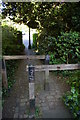
10
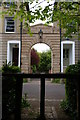
The Terrace, Park Town, North Oxford
At the east end of Park Town, a small garden the shape of a flattened semi-circle is faced by a crescent of Regency-style houses; a path cuts through the garden and aligns with an arch at a break in the crescent. Beyond the arch lies a public footpath along the back of the buildings, part of a cycle route from the town centre to North Oxford.
As the date over the arch indicates, The Terrace (the crescent of buildings) dates from 1855.
Image: © Christopher Hilton
Taken: 4 May 2017
0.07 miles