IMAGES TAKEN NEAR TO
Kingston Road, OXFORD, OX2 6RJ
Introduction
This page details the photographs taken nearby to Kingston Road, OX2 6RJ by members of the Geograph project.
The Geograph project started in 2005 with the aim of publishing, organising and preserving representative images for every square kilometre of Great Britain, Ireland and the Isle of Man.

There are currently over 7.5m images from over14,400 individuals and you can help contribute to the project by visiting https://www.geograph.org.uk
Image Map
Images are licensed for reuse under creativecommons.org/licenses/by-sa/2.0
Notes
- Clicking on the map will re-center to the selected point.
- The higher the marker number, the further away the image location is from the centre of the postcode.
Image Listing (140 Images Found)
Images are licensed for reuse under creativecommons.org/licenses/by-sa/2.0
Image
Details
Distance
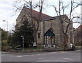
1
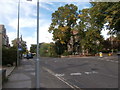
St Margaret's Church
The church is at the junction of Kingston Road and St Margaret's Road. There is an OS benchmark Image on the back of the buttress to the left of the tree.
Image: © Roger Templeman
Taken: 4 Jan 2013
0.01 miles
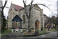
2
Late Victorian St Margaret's Church, Oxford
St Margaret's is an Anglican Parish Church in the north of Oxford, at the junction of Kingston Road and St Margaret's Road. After nearly a decade of construction work, the service of consecration took place on November 22nd 1893.
Image: © Jaggery
Taken: 31 Mar 2013
0.02 miles
3
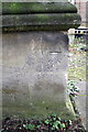
Benchmark on buttress of St Margaret's Church
Ordnance Survey cut mark benchmark described on the Bench Mark Database at http://www.bench-marks.org.uk/bm46690
Image: © Roger Templeman
Taken: 4 Jan 2013
0.02 miles
4
St Margaret's Church
With neither spire nor tower, and hiding coyly behind some trees, St Margaret's Church is not conspicuous. I visited late in the afternoon on my 'Ride & Stride 2019' sponsored walk and was refreshed with the regulation squash and biscuits that Oxford churches provide for this event. The church, whose foundation stone was laid on 8 May 1883, was originally a daughter church of St Philip & St James on the Woodstock Road, but has outlived it, although it is now part of a benefice with St Giles. https://www.stmargaretsoxford.org/the-church/the-history-of-the-parish/
Image: © HelenK
Taken: 14 Sep 2019
0.02 miles
5

Crucifix outside St Margaret's Church
Image: © Steve Daniels
Taken: 13 Mar 2010
0.03 miles

7
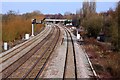
Looking down the line to Aristotle Lane bridge
Image: © Steve Daniels
Taken: 13 Mar 2010
0.05 miles
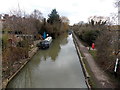
8
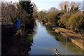
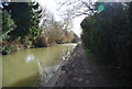
The Oxford Canal from Aristotle Lane Bridge looking south
Image: © Steve Daniels
Taken: 13 Mar 2010
0.05 miles
9
South along the Oxford Canal from Aristotle Bridge, Oxford
Viewed from this http://www.geograph.org.uk/photo/4091063 bridge.
Image: © Jaggery
Taken: 31 Mar 2013
0.05 miles