IMAGES TAKEN NEAR TO
Kingston Road, OXFORD, OX2 6RH
Introduction
This page details the photographs taken nearby to Kingston Road, OX2 6RH by members of the Geograph project.
The Geograph project started in 2005 with the aim of publishing, organising and preserving representative images for every square kilometre of Great Britain, Ireland and the Isle of Man.

There are currently over 7.5m images from over14,400 individuals and you can help contribute to the project by visiting https://www.geograph.org.uk
Image Map
Images are licensed for reuse under creativecommons.org/licenses/by-sa/2.0
Notes
- Clicking on the map will re-center to the selected point.
- The higher the marker number, the further away the image location is from the centre of the postcode.
Image Listing (278 Images Found)
Images are licensed for reuse under creativecommons.org/licenses/by-sa/2.0
Image
Details
Distance
1
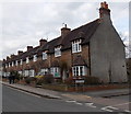
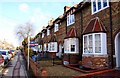
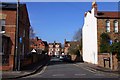
Row of houses, Kingston Road, Oxford
On the east side of Kingston Road, viewed past the Tackley Place junction.
Image: © Jaggery
Taken: 31 Mar 2013
0.01 miles
6
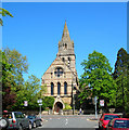
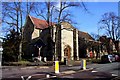
SS. Philip and James
A very large church with interesting interiors on the eastern side of the Woodstock Road
Image: © 2202
Taken: 15 May 2005
0.05 miles
7
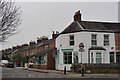
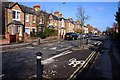
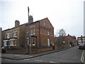
OxFlooring, Oxford
Located at the junction of Kingston Road and Leckford Road.
Image: © Peter Trimming
Taken: 15 Mar 2016
0.05 miles
9
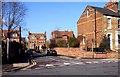
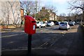
Southmoor Place at the junction of Kingston Road
Image: © David Howard
Taken: 21 Feb 2016
0.06 miles
10
St Margaret's Church in St Margaret's Road
Image: © Steve Daniels
Taken: 13 Mar 2010
0.07 miles