IMAGES TAKEN NEAR TO
Butler Close, OXFORD, OX2 6JQ
Introduction
This page details the photographs taken nearby to Butler Close, OX2 6JQ by members of the Geograph project.
The Geograph project started in 2005 with the aim of publishing, organising and preserving representative images for every square kilometre of Great Britain, Ireland and the Isle of Man.

There are currently over 7.5m images from over14,400 individuals and you can help contribute to the project by visiting https://www.geograph.org.uk
Image Map
Images are licensed for reuse under creativecommons.org/licenses/by-sa/2.0
Notes
- Clicking on the map will re-center to the selected point.
- The higher the marker number, the further away the image location is from the centre of the postcode.
Image Listing (238 Images Found)
Images are licensed for reuse under creativecommons.org/licenses/by-sa/2.0
Image
Details
Distance
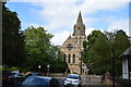
3
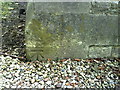
Benchmark on the former Church of SS Philip and James
Ordnance Survey cut mark benchmark described on the Bench Mark Database at http://www.bench-marks.org.uk/bm28723.
Image: © Roger Templeman
Taken: 13 Aug 2010
0.02 miles

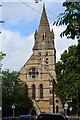
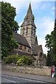
7
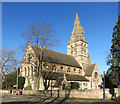
Formerly St Philip & St James
A Victorian Gothic Revival church built in the 1860s.
Since 1983 it has been the Oxford Centre for Mission Studies.
Image: © Des Blenkinsopp
Taken: 18 Feb 2016
0.03 miles