IMAGES TAKEN NEAR TO
Woodstock Road, OXFORD, OX2 6HP
Introduction
This page details the photographs taken nearby to Woodstock Road, OX2 6HP by members of the Geograph project.
The Geograph project started in 2005 with the aim of publishing, organising and preserving representative images for every square kilometre of Great Britain, Ireland and the Isle of Man.

There are currently over 7.5m images from over14,400 individuals and you can help contribute to the project by visiting https://www.geograph.org.uk
Image Map
Images are licensed for reuse under creativecommons.org/licenses/by-sa/2.0
Notes
- Clicking on the map will re-center to the selected point.
- The higher the marker number, the further away the image location is from the centre of the postcode.
Image Listing (220 Images Found)
Images are licensed for reuse under creativecommons.org/licenses/by-sa/2.0
Image
Details
Distance
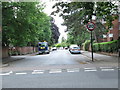
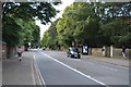
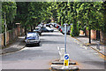
2
Oxford : Farndon Road
Looking along Farndon Road from the junction with Woodstock Road.
Image: © Lewis Clarke
Taken: 29 Jun 2014
0.03 miles
4
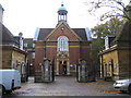
Oxford: St Hugh's College
The College is in St Margaret's Road and its website is here http://www.st-hughs.ox.ac.uk/
Image: © Nigel Cox
Taken: 21 Oct 2006
0.05 miles
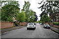
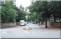
6
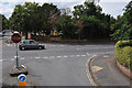
Oxford : St Margaret's Road
Looking towards the road junction from St Margaret's Road and Woodstock Road.
Image: © Lewis Clarke
Taken: 29 Jun 2014
0.06 miles
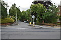
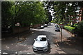
8
St Margaret's Road - Woodstock Road
Image: © Betty Longbottom
Taken: 12 Aug 2013
0.07 miles
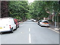
9
Oxford : Saint Margaret's Road
From Woodstock Road looking along Saint Margaret's Road.
Image: © Lewis Clarke
Taken: 29 Jun 2014
0.07 miles
10
St Margaret's Road - Woodstock Road
Image: © Betty Longbottom
Taken: 12 Aug 2013
0.07 miles