IMAGES TAKEN NEAR TO
Walton Street, OXFORD, OX2 6EA
Introduction
This page details the photographs taken nearby to Walton Street, OX2 6EA by members of the Geograph project.
The Geograph project started in 2005 with the aim of publishing, organising and preserving representative images for every square kilometre of Great Britain, Ireland and the Isle of Man.

There are currently over 7.5m images from over14,400 individuals and you can help contribute to the project by visiting https://www.geograph.org.uk
Image Map
Images are licensed for reuse under creativecommons.org/licenses/by-sa/2.0
Notes
- Clicking on the map will re-center to the selected point.
- The higher the marker number, the further away the image location is from the centre of the postcode.
Image Listing (449 Images Found)
Images are licensed for reuse under creativecommons.org/licenses/by-sa/2.0
Image
Details
Distance
1
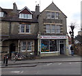
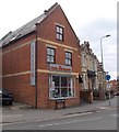
Walton Street Cycles, Jericho, Oxford
Bike shop at 78 Walton Street.
Image: © Jaggery
Taken: 31 Mar 2013
0.01 miles
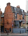
3
Oxford Blueprint board on Sang Hing House, Oxford
At the end of March 2013, there was an Oxford Blueprint Building & Maintenance board
on the Chinese take away at 83 Walton Street. Peppers Burgers shop is next door.
Image: © Jaggery
Taken: 31 Mar 2013
0.02 miles
4

Jericho, Oxford
This unmade road, off Walton Street, leads to the main entrance of St Sepulchre’s cemetery. By 1843 “every churchyard in the city,” a committee reported, “was full” and although the need for new burial grounds was becoming urgent a battle raged over whether to create a large general cemetery versus a number of smaller 'parish cemeteries'. In 1847 a decision was taken to create three smaller cemeteries for the eleven parishes and a district chapelry that comprised the inner city. Thus St Sepulchre's cemetery was born at the extreme north-west of the St Paul’s ecclesiastical sub-district. This was previously the site of an old farmstead that had been abandoned in the early C19th, belonging to Walton Manor Farm. The cemetery was also used by seven of the city colleges who were no longer allowed to bury their dead in their own chapels. This new burial ground was consecrated 1848 and although it was extended later it was finally closed for new burials in 1945 when it became the responsibility of the City Council.
Image: © David Hallam-Jones
Taken: 29 Jul 2013
0.02 miles
5

Benchmark and SV sign on #73 Walton Street
The Ordnance Survey cut mark benchmark (part of which is visible to the left of and below the sign) is described on the Bench Mark Database at http://www.bench-marks.org.uk/bm46709
Image: © Roger Templeman
Taken: 4 Jan 2013
0.02 miles
6
#73 Walton Street at Juxon Street junction
There is an OS benchmark Image under the Stop Valve sign
Image: © Roger Templeman
Taken: 4 Jan 2013
0.02 miles
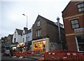
7
Juxon Street, Oxford
From the corner of Allam Street looking along Juxon Street towards Walton Street.
Image: © Jaggery
Taken: 31 Mar 2013
0.02 miles
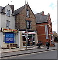
8
Cycle Centre, Oxford
Bike shop at 86 Walton Street.
Image: © Jaggery
Taken: 31 Mar 2013
0.02 miles
9
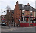
The Victoria, Oxford
The pub on the corner of Walton Street and St Bernard's Road is easy to find because it's opposite this pink shop. http://www.geograph.org.uk/photo/4090599
Image: © Jaggery
Taken: 31 Mar 2013
0.03 miles