IMAGES TAKEN NEAR TO
Cardigan Street, OXFORD, OX2 6BS
Introduction
This page details the photographs taken nearby to Cardigan Street, OX2 6BS by members of the Geograph project.
The Geograph project started in 2005 with the aim of publishing, organising and preserving representative images for every square kilometre of Great Britain, Ireland and the Isle of Man.

There are currently over 7.5m images from over14,400 individuals and you can help contribute to the project by visiting https://www.geograph.org.uk
Image Map
Images are licensed for reuse under creativecommons.org/licenses/by-sa/2.0
Notes
- Clicking on the map will re-center to the selected point.
- The higher the marker number, the further away the image location is from the centre of the postcode.
Image Listing (512 Images Found)
Images are licensed for reuse under creativecommons.org/licenses/by-sa/2.0
Image
Details
Distance
1
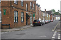
Jericho
Looking along Canal Street from the junction with Cardigan Street. The building on the left is the Jericho St Barnabas Community Centre.
Image: © Stephen McKay
Taken: 4 Jul 2007
0.01 miles
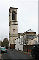
2
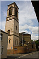
St. Barnabas
Located beside Canal Street the church is built in the style of a basilica. It is difficult to photograph being hemmed in by the close-knit streets of the Jericho area of Oxford. The church was built in 1868/9 at the expense of local printer Thomas Combe, with the support of his wife Martha. Both were members of the Oxford Movement and are commemorated by a blue plaque on the side of the bell tower, see Image The church remains a place of Anglican Catholic worship to this day. A view of its interior can be seen at - Image
Image: © Martin Addison
Taken: 11 Aug 2010
0.02 miles
3
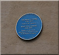
Blue Plaque, Cardigan Street
Located on the bell tower of St. Barnabas church to commemorate its founders. For a view of the church see Image
Image: © Martin Addison
Taken: 11 Aug 2010
0.02 miles
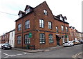
4
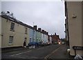
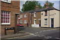
Cardigan Street at the junction of Albert Street
Image: © David Howard
Taken: 21 Feb 2016
0.02 miles
6
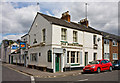
Old Bookbinders
A Greene King public house on the corner of Victor Street and Canal Street. A fitting name perhaps - given the proximity of The Oxford University Press on Walton Street. This public house appeared in the first television Inspector Morse episode, The Dead of Jericho.
Image: © Martin Addison
Taken: 11 Aug 2010
0.03 miles
7
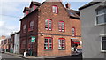
Jericho St Barnabas Community Centre, Oxford
On the corner of Cardigan Street and Canal Street, opposite St Barnabas Church.
Image: © Jaggery
Taken: 31 Mar 2013
0.03 miles
9
Jericho
Showing the Great Clarendon Street/Albert Street junction. Jericho, an area of tightly packed Victorian terraced housing (interspersed with the occasional more modern building) sandwiched between Walton Street and the Oxford Canal, was originally named after a local pub - although it is sometimes said that it was so-called because the houses were jerry built. Although originally a working class district, its proximity to central Oxford has meant inevitable gentrification.
Image: © Stephen McKay
Taken: 4 Jul 2007
0.03 miles
10
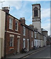
Canal Street, Jericho, Oxford
Looking towards this http://www.geograph.org.uk/photo/4089059 church tower.
Image: © Jaggery
Taken: 31 Mar 2013
0.03 miles