IMAGES TAKEN NEAR TO
Mount Place, OXFORD, OX2 6BJ
Introduction
This page details the photographs taken nearby to Mount Place, OX2 6BJ by members of the Geograph project.
The Geograph project started in 2005 with the aim of publishing, organising and preserving representative images for every square kilometre of Great Britain, Ireland and the Isle of Man.

There are currently over 7.5m images from over14,400 individuals and you can help contribute to the project by visiting https://www.geograph.org.uk
Image Map
Images are licensed for reuse under creativecommons.org/licenses/by-sa/2.0
Notes
- Clicking on the map will re-center to the selected point.
- The higher the marker number, the further away the image location is from the centre of the postcode.
Image Listing (466 Images Found)
Images are licensed for reuse under creativecommons.org/licenses/by-sa/2.0
Image
Details
Distance
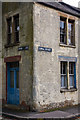
1
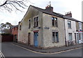
Weathered corner in Jericho, Oxford
The corner of Canal Street and Mount Place.
Image: © Jaggery
Taken: 31 Mar 2013
0.00 miles
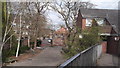
3
Mount Street towards Mount Place, Jericho, Oxford
Viewed from the Allam Street end of Mount Street.
Image: © Jaggery
Taken: 31 Mar 2013
0.02 miles
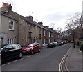
4
Canal Street, Jericho
Bicycles propped against the walls of terraced houses are characteristic of the Jericho area. This is the northern end of Canal Street.
Image: © Stephen McKay
Taken: 4 Jul 2007
0.02 miles
5
Jericho, Oxford
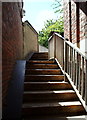
A number of wheel ramps enable cyclists to manoeuvre their bikes over this footbridge from Mount Place, Jericho to the towpath beside the Oxford Canal (ahead). In April 1859 a request was made to the Oxford Canal Company to erect a bridge across the canal. However, the Company rejected this due to concerns that a bridge was likely to lead an increase in trespassers on the towpath. In 1868 a public ferry service began operating from the end of nearby Combe Road (referred to as Ferry Road at the time). This service continued for almost 100 years until it was replaced by the Mount Place footbridge in 1972. Mount Place, a small Square at the foot of these stairs, links to Canal Street.
Image: © David Hallam-Jones
Taken: 29 Jul 2013
0.02 miles
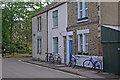
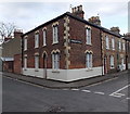
6
Old House, Jericho
Standing on the corner of Canal Street and Mount Place.
Image: © Martin Addison
Taken: 11 Aug 2010
0.03 miles
7
Corner of Canal Street and Cranham Street, Jericho, Oxford
Viewed across Canal Street near the Oxford Canal.
Image: © Jaggery
Taken: 31 Mar 2013
0.03 miles
8
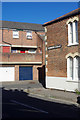
Cranham Street, Jericho
Jericho consists mainly of small terraced houses built for the working class of Oxford in the 19th century. By the 1960s it had become run down and there were plans for comprehensive redevelopment. This never happened and instead many of the houses were refurbished, although the worst cases were demolished and replaced by modern buildings; nowadays the area is populated largely by young professionals and is regarded as a prime example of urban regeneration. In this view, examples of old and new housing can be seen where Cranham Street meets Canal Street.
Image: © Stephen McKay
Taken: 11 Jul 2020
0.03 miles
10
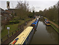
Oxford Canal near Jericho
Looking towards the College Cruisers boatyard from the footbridge. The Tower of St Barnabas Church is to the left.
Image: © Paul Harrop
Taken: 18 Mar 2011
0.03 miles