IMAGES TAKEN NEAR TO
Kestrel Way, BICESTER, OX26 6XZ
Introduction
This page details the photographs taken nearby to Kestrel Way, OX26 6XZ by members of the Geograph project.
The Geograph project started in 2005 with the aim of publishing, organising and preserving representative images for every square kilometre of Great Britain, Ireland and the Isle of Man.

There are currently over 7.5m images from over14,400 individuals and you can help contribute to the project by visiting https://www.geograph.org.uk
Image Map
Images are licensed for reuse under creativecommons.org/licenses/by-sa/2.0
Notes
- Clicking on the map will re-center to the selected point.
- The higher the marker number, the further away the image location is from the centre of the postcode.
Image Listing (24 Images Found)
Images are licensed for reuse under creativecommons.org/licenses/by-sa/2.0
Image
Details
Distance
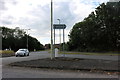
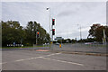
2
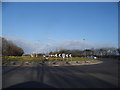
Roundabout on Wretchwick Way, Bicester
Image: © David Howard
Taken: 20 Mar 2016
0.10 miles
3
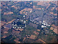
Bicester and the DSDC
The Defence Storage and Distribution Centre at Bicester which, according to the map, looks like a full sized and extensive train set.
Image: © M J Richardson
Taken: 5 Sep 2013
0.10 miles
4
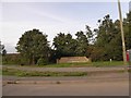
Modern sign for Langford Village
The new Langford Village is a large development with its own school and shopping centre
Image: © David Smith
Taken: 24 Aug 2017
0.11 miles
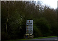
7
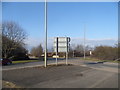
The exit to Bicester on the A41
Turn right
Image: © David Howard
Taken: 20 Mar 2016
0.15 miles