IMAGES TAKEN NEAR TO
Merganser Drive, BICESTER, OX26 6UG
Introduction
This page details the photographs taken nearby to Merganser Drive, OX26 6UG by members of the Geograph project.
The Geograph project started in 2005 with the aim of publishing, organising and preserving representative images for every square kilometre of Great Britain, Ireland and the Isle of Man.

There are currently over 7.5m images from over14,400 individuals and you can help contribute to the project by visiting https://www.geograph.org.uk
Image Map
Images are licensed for reuse under creativecommons.org/licenses/by-sa/2.0
Notes
- Clicking on the map will re-center to the selected point.
- The higher the marker number, the further away the image location is from the centre of the postcode.
Image Listing (15 Images Found)
Images are licensed for reuse under creativecommons.org/licenses/by-sa/2.0
Image
Details
Distance
2
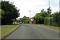
Sheerwater Drive, Bicester
Looking down Sheerwater Drive, Bicester.
Image: © Len Williams
Taken: 13 Apr 2014
0.14 miles
4
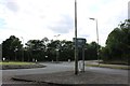
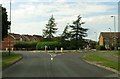
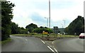
Roundabout on Charbridge Lane, Bicester
Image: © David Howard
Taken: 8 Jun 2019
0.16 miles
6
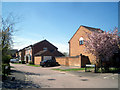
Sandpiper Close
A short residential street typical of the recent development in this part of town.
Image: © Des Blenkinsopp
Taken: 20 Apr 2010
0.17 miles
7
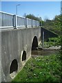
The Langford Brook under Gavray Drive
This is the stream that caused the Environment Agency to put in the flood warning station shown in Image
This is taken after a dry spell. The gauge board is only just in the water.
But you can see the kind of flows that the bridge has been constructed to cater for by looking at the size of the main arch and the side channels.
And Gavray Drive ? Sounds like one of those forename compound words, like it was built by two guys called Gavin and Raymond, but actually it's named after a town in Normandy.
Image: © Des Blenkinsopp
Taken: 20 Apr 2010
0.20 miles
9

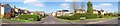
Jubilee Lake, Bicester
The Northern end of Jubilee Lake, Langford Village, Bicester. For a view down the lake refer to pictureImage
Image: © Len Williams
Taken: 13 Apr 2014
0.20 miles
10
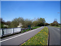
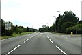
Langford Flood Warning Station
After heavy rain the Langford Brook, which goes under the road just here, sometimes forgets what its banks are for and spreads out a bit.
The Environment Agency have put in an early warning station which is in the green kiosk. This automatically raises an alarm when the water reaches a certain level.
And changing the subject, wouldn't it be nice if there were more cycleways like this one.
Image: © Des Blenkinsopp
Taken: 20 Apr 2010
0.21 miles