IMAGES TAKEN NEAR TO
Corncrake Way, BICESTER, OX26 6UF
Introduction
This page details the photographs taken nearby to Corncrake Way, OX26 6UF by members of the Geograph project.
The Geograph project started in 2005 with the aim of publishing, organising and preserving representative images for every square kilometre of Great Britain, Ireland and the Isle of Man.

There are currently over 7.5m images from over14,400 individuals and you can help contribute to the project by visiting https://www.geograph.org.uk
Image Map
Images are licensed for reuse under creativecommons.org/licenses/by-sa/2.0
Notes
- Clicking on the map will re-center to the selected point.
- The higher the marker number, the further away the image location is from the centre of the postcode.
Image Listing (27 Images Found)
Images are licensed for reuse under creativecommons.org/licenses/by-sa/2.0
Image
Details
Distance
1
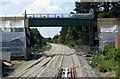
The new footbridge replacing Tubbs Crossing
The bridge has ramps for the disabled.
Image: © Steve Daniels
Taken: 23 Jun 2014
0.08 miles
2
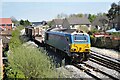
67003 with a short freight train for Bicester MOD Depot
Class 67 No. 67003 negotiates the new Gavray Junction, western end of the Bicester Chord line. As the line from Oxford to Bicester was still being rebuilt, freight trains for Bicester MOD Depot were routed via Aylesbury, Claydon Junction (where the trains reversed) and Bicester Town. At this time, Gavray Junction was still under construction, the track only recently having been laid, so movements off the old LNWR line from Bletchley and Claydon had to be taken at a very slow speed. As soon as the Bicester Chord was operational, these trains reverted to the route via Oxford. Subsequently the track between here and Bletchley was lifted to allow this section to be rebuilt to double track mainline standard for East West Railway which will run trains from Milton Keynes to Oxford and to London via Aylesbury.
Image: © Bob Walters
Taken: 23 Apr 2015
0.09 miles
3
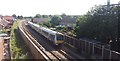
View from Launton Road Footbridge
View from Launton Road Footbridge a Chiltern Railway train heading towards Bicester Village Station
Image: © Shaun Ferguson
Taken: 3 Jul 2019
0.10 miles
4

'Flying Scotsman'
Seen passing Bicester (14:07) with a tour from Paddington to Victoria via Oxford. The locomotive hauled a second tour during the evening.
Image: © Peter Trimming
Taken: 5 Jun 2018
0.10 miles
5
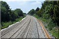
The renovated rail line through Bicester
The line from Oxford to Bicester is being twin lined to take trains to London Marylebone.
Image: © Steve Daniels
Taken: 23 Jun 2014
0.13 miles
7

Dog's gravestones in Garth Park
The dog cemetery was for the pets of the former owners of the Garth.
Image: © Steve Daniels
Taken: 26 Feb 2021
0.15 miles
8
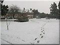
The Garth
A very snowy scene of The Garth (know locally as 'Garth Park'). This old house is the home of Bicester Town Council. The park is of a good size featuring a playground, pond, large lawned areas, many varieties of trees and plants, and even a small ancient graveyard!
Image: © Kurt C
Taken: 2 Feb 2009
0.16 miles
9
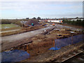
Railway construction northeast of Bicester, 7 February 2014
The immediate view, from a London-bound Chiltern Railways train, is of the site of a new rail link between Bicester Town station and the Chiltern Line. It will allow Chiltern to run services between Marylebone and Oxford. In railway circles, I understand, this link is called the Bicester Chord. This view is roughly the reverse of Image
The bigger picture is that this is part of the EastWest Rail Project to connect East Anglia with central, southern and western England http://www.eastwestrail.org.uk Thanks to Andrew Bodman for information. He is photographing other parts of the undertaking http://www.geograph.org.uk/search.php?i=51155856
Image: © Robin Stott
Taken: 7 Feb 2014
0.16 miles