IMAGES TAKEN NEAR TO
Peregrine Way, BICESTER, OX26 6SX
Introduction
This page details the photographs taken nearby to Peregrine Way, OX26 6SX by members of the Geograph project.
The Geograph project started in 2005 with the aim of publishing, organising and preserving representative images for every square kilometre of Great Britain, Ireland and the Isle of Man.

There are currently over 7.5m images from over14,400 individuals and you can help contribute to the project by visiting https://www.geograph.org.uk
Image Map
Images are licensed for reuse under creativecommons.org/licenses/by-sa/2.0
Notes
- Clicking on the map will re-center to the selected point.
- The higher the marker number, the further away the image location is from the centre of the postcode.
Image Listing (15 Images Found)
Images are licensed for reuse under creativecommons.org/licenses/by-sa/2.0
Image
Details
Distance


4
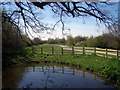
Pond near Langford Village
This pond is in an area of linear parkland between extensive recent housing developments. The park is there mainly because of the Langford Brook which flows the other side of the cycleway in this pic.
Normally a small stream, it can be prone to extensive flash flooding so housing has been kept away from a considerable area of flood plain on both sides.
There are a number of small ponds around this area. The Environment Agency has done a lot of work on the stream to improve its drainage capabilities while retaining a natural looking course, which is why the cycleway meanders a bit as it follows it along.
Image: © Des Blenkinsopp
Taken: 21 Apr 2010
0.14 miles
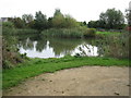
9

Jubilee Lake, Bicester
Jubilee Lake in Langford Village, Bicester, was opened in 1992. Apart from a place of relaxation it also acts as a flood protection reservoir. For another view refer to picture Image
Image: © Len Williams
Taken: 14 Apr 2014
0.20 miles
10
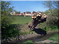
Pollarded Willow
Someone's set about this poor old tree beside the Langford Brook.
New housing in the background just raised up slightly, so any flood water spreads out over the football pitch.
Image: © Des Blenkinsopp
Taken: 20 Apr 2010
0.21 miles