IMAGES TAKEN NEAR TO
Maple Road, BICESTER, OX26 6QX
Introduction
This page details the photographs taken nearby to Maple Road, OX26 6QX by members of the Geograph project.
The Geograph project started in 2005 with the aim of publishing, organising and preserving representative images for every square kilometre of Great Britain, Ireland and the Isle of Man.

There are currently over 7.5m images from over14,400 individuals and you can help contribute to the project by visiting https://www.geograph.org.uk
Image Map
Images are licensed for reuse under creativecommons.org/licenses/by-sa/2.0
Notes
- Clicking on the map will re-center to the selected point.
- The higher the marker number, the further away the image location is from the centre of the postcode.
Image Listing (132 Images Found)
Images are licensed for reuse under creativecommons.org/licenses/by-sa/2.0
Image
Details
Distance
1
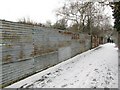
'Town Walk' Foot/Cycle Path
This picture is the view NE up the main walkway and cyclepath joining Withington Road (and the Town Centre) to the north side of Bicester (via a small short tunnel underneath railway). It is fully fenced off in both directions and on both sides, and is approx 300 yards long. Although it has existed for many years, it has recently been named 'Town Walk', though many locals are indifferent to its name!
Image: © Kurt C
Taken: 2 Feb 2009
0.08 miles
2
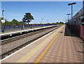
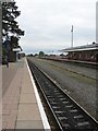
Bicester North railway station
Viewed along platform 1. The edge of a 2-level car park is on the right.
Bicester North is on the Chiltern Main Line. Service are operated by Chiltern Railways -
south to London Marylebone (ahead), north to Banbury, Stratford-upon-Avon and Birmingham Snow Hill.
Image: © Jaggery
Taken: 9 Jul 2015
0.09 miles
3
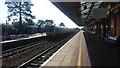
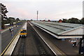
Bicester North Railway Station
A Marylebone Chiltern Railway service leaving Bicester North Railway Station
Image: © Shaun Ferguson
Taken: 3 Jul 2019
0.10 miles
4
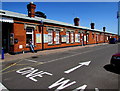
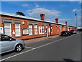
Main building at Bicester North railway station
On the south side of the station, viewed from Chiltern Approach.
Image: © Jaggery
Taken: 9 Jul 2015
0.10 miles
6
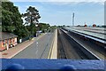
South from Bicester North
All the signals are red. The Chiltern main line to London Marylebone was closed for works to the track in several locations. Rail Replacement buses were operating from Aylesbury Parkway to Bicester for trains towards Birmingham. The replacement bus service always strikes me as, contrary to stereotype, well organised, safe and comfortable with helpful staff always on hand. Journeys take longer of course but they do take place. Engineering work is essential to maintain the safety of the network.
Image: © Robin Stott
Taken: 1 Sep 2024
0.11 miles
10
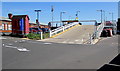
Ramp access to a parking area outside Bicester North railway station
From Chiltern Approach. Maximum speed 5 mph.
Image: © Jaggery
Taken: 9 Jul 2015
0.11 miles