IMAGES TAKEN NEAR TO
Victoria Road, BICESTER, OX26 6PH
Introduction
This page details the photographs taken nearby to Victoria Road, OX26 6PH by members of the Geograph project.
The Geograph project started in 2005 with the aim of publishing, organising and preserving representative images for every square kilometre of Great Britain, Ireland and the Isle of Man.

There are currently over 7.5m images from over14,400 individuals and you can help contribute to the project by visiting https://www.geograph.org.uk
Image Map
Images are licensed for reuse under creativecommons.org/licenses/by-sa/2.0
Notes
- Clicking on the map will re-center to the selected point.
- The higher the marker number, the further away the image location is from the centre of the postcode.
Image Listing (134 Images Found)
Images are licensed for reuse under creativecommons.org/licenses/by-sa/2.0
Image
Details
Distance
1
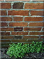
Bicester, Benchmark at 1 Newport Terrace (Victoria Road)
Ordnance Survey 1968 cut mark benchmark on wall of 1 Newport Terrace. See http://www.bench-marks.org.uk/bm33915
Image: © Roger Templeman
Taken: 9 Apr 2010
0.05 miles
2
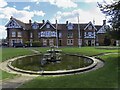
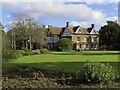
The Garth in Bicester
The Garth houses the Registry Office and Council Offices.
Image: © Steve Daniels
Taken: 26 Feb 2021
0.09 miles
3
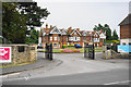
Bicester Town Council Offices
Adjoining Garth Park.
Image: © Bill Boaden
Taken: 26 Jun 2015
0.09 miles
4
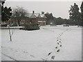
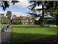
The Garth
A very snowy scene of The Garth (know locally as 'Garth Park'). This old house is the home of Bicester Town Council. The park is of a good size featuring a playground, pond, large lawned areas, many varieties of trees and plants, and even a small ancient graveyard!
Image: © Kurt C
Taken: 2 Feb 2009
0.09 miles
5
The Garth in Bicester
The Garth houses the Registry Office and Council Offices.
Image: © Steve Daniels
Taken: 26 Feb 2021
0.09 miles
6
The Garth in Bicester
The Garth houses the Registry Office and Council Offices.
Image: © Steve Daniels
Taken: 26 Feb 2021
0.09 miles

8
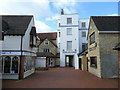
Dean's Yard, Bicester
Businesses clustered around an alley leading from one of the town's car parks.
Image: © Jonathan Billinger
Taken: 1 Oct 2008
0.10 miles
10
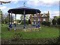
Bandstand in Garth Park
The bandstand, built in the 1920s, was originally erected in a suburb of Barnsley. Declared as scrap, it was purchased and renovated by Bicester Town Council.
Image: © Steve Daniels
Taken: 26 Feb 2021
0.11 miles